
 Gilserberg
Berlin
Bordesholm
Bechtolsheim
Aub
Triptis
Heppenheim
Biblis
Angermünde
Gilserberg
Berlin
Bordesholm
Bechtolsheim
Aub
Triptis
Heppenheim
Biblis
Angermünde
Hermann-Löns-Park on the map, Hanover, Germany
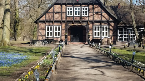
Photo
Where is located Hermann-Löns-Park
Hermann-Löns-Park — local attraction, which is located at Hermann-Löns-Park, 30559 Hannover, Germany and belongs to the category — park. Average visitor rating for this place — 4.6 (according to 1144 ratings, information from open sources and relevant for 2022).
Exact location — Hermann-Löns-Park, marked on the map with a red marker.
You can get directions to Hermann-Löns-Park on the map from your location.
What else is interesting in Hanover? You can see all the sights if you go to the city page.
Coordinates
Hermann-Löns-Park, Germany coordinates in decimal format: latitude — 52.36754782499359, longitude — 9.81527599816829. When converted to degrees, minutes, seconds Hermann-Löns-Park has the following coordinates: 52°22′3.17 north latitude and 9°48′54.99 east longitude.
Nearby cities
The largest cities that are located nearby:
- Hildesheim — 29 km
- Salzgitter — 48 km
- Brunswick — 55 km
- Wolfsburg — 71 km
- Bielefeld — 90 km
- Göttingen — 93 km
- Paderborn — 99 km
- Bremen — 99 km
- Osnabrück — 114 km
- Kassel — 119 km
- Magdeburg — 132 km
- Bremerhaven — 149 km
- Münster — 151 km
- Hamm — 153 km
- Erfurt — 178 km
- Dortmund — 183 km
- Hagen — 192 km
- Enschede
 (Netherlands) — 193 km
 - Recklinghausen — 193 km
Distance to the capital
Distance to the capital (Berlin) is about — 244 km.