
 Puerto de la Duquesa
La Serna de Iguña
Pumalverde
Puentenansa
La Iglesia
Casar de Periedo
Fuengirola
Renedo de Piélagos
Villabanez
Puerto de la Duquesa
La Serna de Iguña
Pumalverde
Puentenansa
La Iglesia
Casar de Periedo
Fuengirola
Renedo de Piélagos
Villabanez
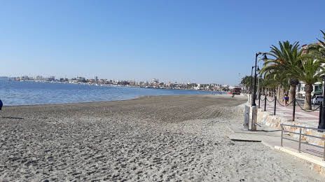
Beach Villananitos (Playa de Villananitos) on the map, San Pedro del Pinatar, Spain
Photo
Where is located Beach Villananitos (Playa de Villananitos)
Beach Villananitos (Playa de Villananitos) — local attraction, which is located at C. Campoamor, 30740 San Pedro del Pinatar, Murcia, Spain and belongs to the category — tourist attraction. Average visitor rating for this place — 4.1 (according to 1109 ratings, information from open sources and relevant for 2022).
Exact location — Beach Villananitos (Playa de Villananitos), marked on the map with a red marker.
You can get directions to Beach Villananitos (Playa de Villananitos) on the map from your location.
What else is interesting in San Pedro del Pinatar? You can see all the sights if you go to the city page.
Coordinates
Beach Villananitos (Playa de Villananitos), Spain coordinates in decimal format: latitude — 37.81930644785848, longitude — -0.7839849021561374. When converted to degrees, minutes, seconds Beach Villananitos (Playa de Villananitos) has the following coordinates: 37°49′9.5 north latitude and -0°47′2.35 east longitude.
Nearby cities
The largest cities that are located nearby:
- Cartagena — 29 km
- Murcia — 34 km
- Albacete — 158 km
- Valencia — 184 km
- Almería — 185 km
- Oran
 (Algeria) — 237 km
 - Granada — 258 km
- Jaén — 262 km
- Relizane (Algeria) — 262 km
- Chlef (Algeria) — 265 km
- Sidi Bel Abbes (Algeria) — 292 km
- Tlemcen (Algeria) — 330 km
- Saida (Algeria) — 342 km
- Málaga — 344 km
- Córdoba — 348 km
- Palma — 350 km
- Nador
 (Morocco) — 353 km
 - Algiers (Algeria) — 360 km
- Médéa (Algeria) — 360 km
Distance to the capital
Distance to the capital (Madrid) is about — 383 km.