
 Gilserberg
Berlin
Bordesholm
Bechtolsheim
Aub
Triptis
Heppenheim
Biblis
Angermünde
Gilserberg
Berlin
Bordesholm
Bechtolsheim
Aub
Triptis
Heppenheim
Biblis
Angermünde
Simetsberg on the map, Garmisch-Partenkirchen, Germany
Photo
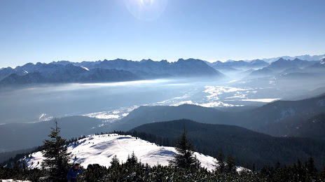
Where is located Simetsberg
Simetsberg — local attraction, which is located at 1,836 m and belongs to the category — -. Average visitor rating for this place — 4.3 (according to 14 ratings, information from open sources and relevant for 2022).
Exact location — Simetsberg, marked on the map with a red marker.
You can get directions to Simetsberg on the map from your location.
What else is interesting in Garmisch-Partenkirchen? You can see all the sights if you go to the city page.
Coordinates
Simetsberg, Germany coordinates in decimal format: latitude — 47.568859026839206, longitude — 11.254999883760002. When converted to degrees, minutes, seconds Simetsberg has the following coordinates: 47°34′7.89 north latitude and 11°15′18 east longitude.
Nearby cities
The largest cities that are located nearby:
- Innsbruck
 (Austria) — 34 km
 - Munich — 80 km
- Augsburg — 98 km
- Ulm — 129 km
- Ingolstadt — 143 km
- Salzburg (Austria) — 150 km
- Trento
 (Italy) — 157 km
 - Reutlingen — 178 km
- Regensburg — 183 km
- Zurich
 (Switzerland) — 192 km
 - Stuttgart — 199 km
- Nuremberg — 217 km
- Vicenza (Italy) — 218 km
- Fürth — 220 km
- Brescia (Italy) — 226 km
- Bergamo (Italy) — 227 km
- Verona (Italy) — 227 km
- Heilbronn — 228 km
- Erlangen — 232 km
Distance to the capital
Distance to the capital (Berlin) is about — 572 km.