
 Gilserberg
Berlin
Bordesholm
Bechtolsheim
Aub
Triptis
Heppenheim
Biblis
Angermünde
Gilserberg
Berlin
Bordesholm
Bechtolsheim
Aub
Triptis
Heppenheim
Biblis
Angermünde
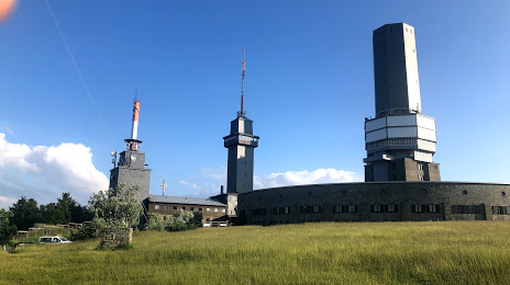
Großer Feldberg - Schmitten on the map, Oberursel, Germany
Photo
Where is located Großer Feldberg - Schmitten
Großer Feldberg - Schmitten — local attraction, which is located at Großer Feldberg, 61389 Schmitten, Germany and belongs to the category — ski resort. Average visitor rating for this place — 4.7 (according to 6 ratings, information from open sources and relevant for 2022).
Exact location — Großer Feldberg - Schmitten, marked on the map with a red marker.
You can get directions to Großer Feldberg - Schmitten on the map from your location.
What else is interesting in Oberursel? You can see all the sights if you go to the city page.
Coordinates
Großer Feldberg - Schmitten, Germany coordinates in decimal format: latitude — 50.233612523520605, longitude — 8.458055488567508. When converted to degrees, minutes, seconds Großer Feldberg - Schmitten has the following coordinates: 50°14′1.01 north latitude and 8°27′29 east longitude.
Nearby cities
The largest cities that are located nearby:
- Frankfurt — 13 km
- Offenbach — 18 km
- Wiesbaden — 28 km
- Mainz — 33 km
- Darmstadt — 37 km
- Koblenz — 72 km
- Mannheim — 79 km
- Ludwigshafen — 81 km
- Siegen — 85 km
- Heidelberg — 89 km
- Würzburg — 108 km
- Bonn — 119 km
- Heilbronn — 126 km
- Karlsruhe — 133 km
- Bergisch Gladbach — 133 km
- Kassel — 138 km
- Cologne — 139 km
- Remscheid — 145 km
- Pforzheim — 145 km
Distance to the capital
Distance to the capital (Berlin) is about — 427 km.