
 Gilserberg
Berlin
Bordesholm
Bechtolsheim
Aub
Triptis
Heppenheim
Biblis
Angermünde
Gilserberg
Berlin
Bordesholm
Bechtolsheim
Aub
Triptis
Heppenheim
Biblis
Angermünde
Grabenhäusle on the map, Neu-Ulm, Germany
Photo
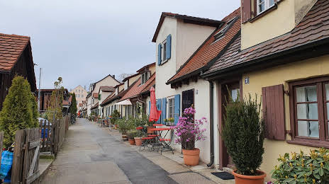
Where is located Grabenhäusle
Grabenhäusle — local attraction, which is located at 89073, Seelengraben, 89073 Ulm, Germany and belongs to the category — historical landmark. Average visitor rating for this place — 4.9 (according to 13 ratings, information from open sources and relevant for 2022).
Exact location — Grabenhäusle, marked on the map with a red marker.
You can get directions to Grabenhäusle on the map from your location.
What else is interesting in Neu-Ulm? You can see all the sights if you go to the city page.
Coordinates
Grabenhäusle, Germany coordinates in decimal format: latitude — 48.40153076455286, longitude — 9.998577898024768. When converted to degrees, minutes, seconds Grabenhäusle has the following coordinates: 48°24′5.51 north latitude and 9°59′54.88 east longitude.
Nearby cities
The largest cities that are located nearby:
- Ulm — 2 km
- Reutlingen — 60 km
- Augsburg — 66 km
- Stuttgart — 74 km
- Heilbronn — 101 km
- Pforzheim — 110 km
- Ingolstadt — 112 km
- Munich — 120 km
- Karlsruhe — 135 km
- Fürth — 139 km
- Nuremberg — 140 km
- Heidelberg — 147 km
- Erlangen — 151 km
- Würzburg — 155 km
- Zurich
 (Switzerland) — 158 km
 - Innsbruck
 (Austria) — 162 km
 - Mannheim — 164 km
- Ludwigshafen — 164 km
- Freiburg — 166 km
Distance to the capital
Distance to the capital (Berlin) is about — 518 km.