
 Józefów nad Wisłą
Gorzyce Wielkie
Rogówek
Sromowce Niżne
Wyszków County
Kruszewo
Jantar
Sady Górne
Nagoszewo
Józefów nad Wisłą
Gorzyce Wielkie
Rogówek
Sromowce Niżne
Wyszków County
Kruszewo
Jantar
Sady Górne
Nagoszewo
Skansen Archeologiczny „Karpacka Troja” on the map, Jaslo, Poland
Photo
Where is located Skansen Archeologiczny „Karpacka Troja”
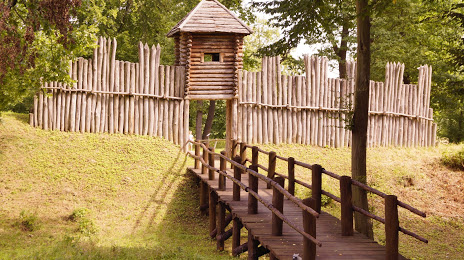
Skansen Archeologiczny „Karpacka Troja” — local attraction, which is located at Trzcinica 646, 38-207 Trzcinica, Poland and belongs to the category — open air museum. Average visitor rating for this place — 4.6 (according to 1568 ratings, information from open sources and relevant for 2022).
Exact location — Skansen Archeologiczny „Karpacka Troja”, marked on the map with a red marker.
You can get directions to Skansen Archeologiczny „Karpacka Troja” on the map from your location.
What else is interesting in Jaslo? You can see all the sights if you go to the city page.
Coordinates
Skansen Archeologiczny „Karpacka Troja”, Poland coordinates in decimal format: latitude — 49.73201780575627, longitude — 21.43321039807197. When converted to degrees, minutes, seconds Skansen Archeologiczny „Karpacka Troja” has the following coordinates: 49°43′55.26 north latitude and 21°25′59.56 east longitude.
Nearby cities
The largest cities that are located nearby:
- Tarnow — 45 km
- Rzeszow — 50 km
- Kraków — 114 km
- Košice
 (Slovakia) — 114 km
 - Kielce — 137 km
- Uzhhorod
 (Ukraine) — 138 km
 - Bielsko-Biala — 172 km
- Dabrowa Gornicza — 173 km
- Sosnowiec — 178 km
- Katowice — 182 km
- Lublin — 183 km
- Radom — 185 km
- Chorzow — 188 km
- Miskolc
 (Hungary) — 190 km
 - Bytom — 192 km
- Ruda Slaska — 193 km
- Nyíregyháza (Hungary) — 199 km
- Zabrze — 200 km
- Częstochowa — 202 km
Distance to the capital
Distance to the capital (Warsaw) is about — 279 km.