
 Puerto de la Duquesa
La Serna de Iguña
Pumalverde
Puentenansa
La Iglesia
Casar de Periedo
Fuengirola
Renedo de Piélagos
Villabanez
Puerto de la Duquesa
La Serna de Iguña
Pumalverde
Puentenansa
La Iglesia
Casar de Periedo
Fuengirola
Renedo de Piélagos
Villabanez
Portal de la Rochapea on the map, Pamplona, Spain
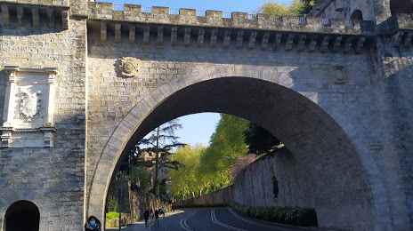
Photo
Where is located Portal de la Rochapea
Portal de la Rochapea — local attraction, which is located at Av. de Gipuzkoa Etorbidea, 31011 Pamplona, Navarra, Spain and belongs to the category — bridge. Average visitor rating for this place — 4.2 (according to 9 ratings, information from open sources and relevant for 2022).
Exact location — Portal de la Rochapea, marked on the map with a red marker.
You can get directions to Portal de la Rochapea on the map from your location.
What else is interesting in Pamplona? You can see all the sights if you go to the city page.
Coordinates
Portal de la Rochapea, Spain coordinates in decimal format: latitude — 42.81860213067041, longitude — -1.6508849021626195. When converted to degrees, minutes, seconds Portal de la Rochapea has the following coordinates: 42°49′6.97 north latitude and -1°39′3.19 east longitude.
Nearby cities
The largest cities that are located nearby:
- San Sebastián — 62 km
- Logroño — 76 km
- Vitoria-Gasteiz — 84 km
- Bilbao — 115 km
- Zaragoza — 143 km
- Burgos — 175 km
- Santander — 188 km
- Lleida — 229 km
- Bordeaux
 (France) — 239 km
 - Toulouse (France) — 262 km
- Valladolid — 285 km
- Alcala de Henares — 295 km
- Alcobendas — 302 km
- Torrejón de Ardoz — 303 km
- Tarragona — 305 km
- León — 320 km
- Leganés — 327 km
- Getafe — 328 km
- Alcorcón — 329 km
Distance to the capital
Distance to the capital (Madrid) is about — 317 km.