
 Józefów nad Wisłą
Gorzyce Wielkie
Rogówek
Sromowce Niżne
Wyszków County
Kruszewo
Jantar
Sady Górne
Nagoszewo
Józefów nad Wisłą
Gorzyce Wielkie
Rogówek
Sromowce Niżne
Wyszków County
Kruszewo
Jantar
Sady Górne
Nagoszewo
Regional Museum in Lukow on the map, Lukow, Poland
Photo
Where is located Regional Museum in Lukow
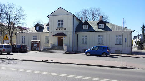
Regional Museum in Lukow — local attraction, which is located at 21-400, Józefa Piłsudskiego 19, Łuków, Poland and belongs to the category — local history museum. Average visitor rating for this place — 4.6 (according to 57 ratings, information from open sources and relevant for 2022).
Exact location — Regional Museum in Lukow, marked on the map with a red marker.
You can get directions to Regional Museum in Lukow on the map from your location.
What else is interesting in Lukow? You can see all the sights if you go to the city page.
Coordinates
Regional Museum in Lukow, Poland coordinates in decimal format: latitude — 51.93037090171737, longitude — 22.37815809815208. When converted to degrees, minutes, seconds Regional Museum in Lukow has the following coordinates: 51°55′49.34 north latitude and 22°22′41.37 east longitude.
Nearby cities
The largest cities that are located nearby:
- Lublin — 76 km
- Brest
 (Belarus) — 94 km
 - Radom — 103 km
- Bialystok — 143 km
- Kielce — 170 km
- Plock — 193 km
- Łódź — 201 km
- Rzeszow — 210 km
- Tarnow — 234 km
- Wloclawek — 236 km
- Olsztyn — 239 km
- Pinsk (Belarus) — 252 km
- Częstochowa — 259 km
- Kraków — 269 km
- Baranovichi (Belarus) — 275 km
- Torun — 279 km
- Dabrowa Gornicza — 287 km
- Sosnowiec — 294 km
- Kalisz — 295 km
Distance to the capital
Distance to the capital (Warsaw) is about — 99 km.