
 Józefów nad Wisłą
Gorzyce Wielkie
Rogówek
Sromowce Niżne
Wyszków County
Kruszewo
Jantar
Sady Górne
Nagoszewo
Józefów nad Wisłą
Gorzyce Wielkie
Rogówek
Sromowce Niżne
Wyszków County
Kruszewo
Jantar
Sady Górne
Nagoszewo
City Park "Alexandria" (Park Miejski Aleksandria) on the map, Siedlce, Poland
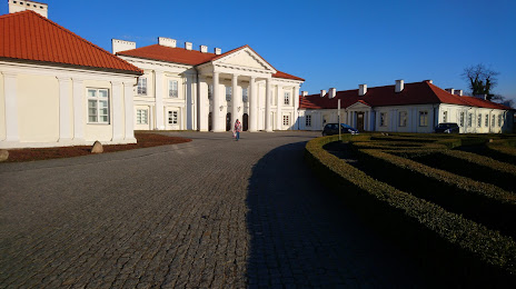
Photo
Where is located City Park "Alexandria" (Park Miejski Aleksandria)
City Park "Alexandria" (Park Miejski Aleksandria) — local attraction, which is located at Stanisława Konarskiego 19, 08-110 Siedlce, Poland and belongs to the category — park. Average visitor rating for this place — 4.1 (according to 666 ratings, information from open sources and relevant for 2022).
Exact location — City Park "Alexandria" (Park Miejski Aleksandria), marked on the map with a red marker.
You can get directions to City Park "Alexandria" (Park Miejski Aleksandria) on the map from your location.
What else is interesting in Siedlce? You can see all the sights if you go to the city page.
Coordinates
City Park "Alexandria" (Park Miejski Aleksandria), Poland coordinates in decimal format: latitude — 52.17157440964697, longitude — 22.28609779831948. When converted to degrees, minutes, seconds City Park "Alexandria" (Park Miejski Aleksandria) has the following coordinates: 52°10′17.67 north latitude and 22°17′9.95 east longitude.
Nearby cities
The largest cities that are located nearby:
- Brest
 (Belarus) — 98 km
 - Lublin — 104 km
- Radom — 116 km
- Bialystok — 122 km
- Plock — 179 km
- Kielce — 185 km
- Łódź — 199 km
- Olsztyn — 214 km
- Wloclawek — 223 km
- Rzeszow — 236 km
- Tarnow — 256 km
- Pinsk (Belarus) — 257 km
- Torun — 263 km
- Częstochowa — 267 km
- Baranovichi (Belarus) — 269 km
- Kraków — 286 km
- Elblag — 289 km
- Kalisz — 291 km
- Dabrowa Gornicza — 299 km
Distance to the capital
Distance to the capital (Warsaw) is about — 87 km.