
 Józefów nad Wisłą
Gorzyce Wielkie
Rogówek
Sromowce Niżne
Wyszków County
Kruszewo
Jantar
Sady Górne
Nagoszewo
Józefów nad Wisłą
Gorzyce Wielkie
Rogówek
Sromowce Niżne
Wyszków County
Kruszewo
Jantar
Sady Górne
Nagoszewo
Zamek Książąt Mazowieckich on the map, Ciechanow, Poland
Photo
Where is located Zamek Książąt Mazowieckich
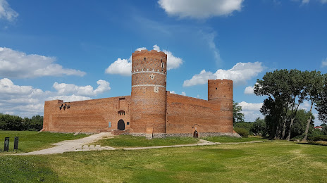
Zamek Książąt Mazowieckich — local attraction, which is located at Zamkowa 1, 06-400 Ciechanów, Poland and belongs to the category — castle. Average visitor rating for this place — 4.5 (according to 2011 ratings, information from open sources and relevant for 2022).
Exact location — Zamek Książąt Mazowieckich, marked on the map with a red marker.
You can get directions to Zamek Książąt Mazowieckich on the map from your location.
What else is interesting in Ciechanow? You can see all the sights if you go to the city page.
Coordinates
Zamek Książąt Mazowieckich, Poland coordinates in decimal format: latitude — 52.884654109841115, longitude — 20.619119498187608. When converted to degrees, minutes, seconds Zamek Książąt Mazowieckich has the following coordinates: 52°53′4.75 north latitude and 20°37′8.83 east longitude.
Nearby cities
The largest cities that are located nearby:
- Plock — 72 km
- Olsztyn — 100 km
- Wloclawek — 107 km
- Torun — 135 km
- Łódź — 147 km
- Elblag — 161 km
- Radom — 167 km
- Bialystok — 171 km
- Bydgoszcz — 175 km
- Kaliningrad
 (Russia) — 203 km
 - Gdańsk — 206 km
- Kalisz — 213 km
- Kielce — 223 km
- Gdynia — 225 km
- Lublin — 226 km
- Brest
 (Belarus) — 229 km
 - Częstochowa — 252 km
- Poznań — 255 km
- Dabrowa Gornicza — 300 km
Distance to the capital
Distance to the capital (Warsaw) is about — 78 km.