
 Józefów nad Wisłą
Gorzyce Wielkie
Rogówek
Sromowce Niżne
Wyszków County
Kruszewo
Jantar
Sady Górne
Nagoszewo
Józefów nad Wisłą
Gorzyce Wielkie
Rogówek
Sromowce Niżne
Wyszków County
Kruszewo
Jantar
Sady Górne
Nagoszewo
Parafia rzymskokatolicka św. Michała Archanioła on the map, Lomza, Poland
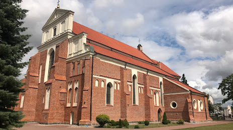
Photo
Where is located Parafia rzymskokatolicka św. Michała Archanioła
Parafia rzymskokatolicka św. Michała Archanioła — local attraction, which is located at Dworna 25, 18-400 Łomża, Poland and belongs to the category — religious institution. Average visitor rating for this place — 4.7 (according to 316 ratings, information from open sources and relevant for 2022).
Exact location — Parafia rzymskokatolicka św. Michała Archanioła, marked on the map with a red marker.
You can get directions to Parafia rzymskokatolicka św. Michała Archanioła on the map from your location.
What else is interesting in Lomza? You can see all the sights if you go to the city page.
Coordinates
Parafia rzymskokatolicka św. Michała Archanioła, Poland coordinates in decimal format: latitude — 53.17768562910016, longitude — 22.079965398198595. When converted to degrees, minutes, seconds Parafia rzymskokatolicka św. Michała Archanioła has the following coordinates: 53°10′39.67 north latitude and 22°4′47.88 east longitude.
Nearby cities
The largest cities that are located nearby:
- Bialystok — 74 km
- Olsztyn — 123 km
- Brest
 (Belarus) — 165 km
 - Plock — 173 km
- Kaliningrad
 (Russia) — 197 km
 - Elblag — 203 km
- Radom — 206 km
- Wloclawek — 209 km
- Lublin — 216 km
- Kaunas
 (Lithuania) — 223 km
 - Torun — 231 km
- Łódź — 237 km
- Gdańsk — 255 km
- Baranovichi (Belarus) — 262 km
- Vilnius (Lithuania) — 265 km
- Bydgoszcz — 269 km
- Gdynia — 271 km
- Kielce — 274 km
- Klaipėda (Lithuania) — 285 km
Distance to the capital
Distance to the capital (Warsaw) is about — 128 km.