
 Józefów nad Wisłą
Gorzyce Wielkie
Rogówek
Sromowce Niżne
Wyszków County
Kruszewo
Jantar
Sady Górne
Nagoszewo
Józefów nad Wisłą
Gorzyce Wielkie
Rogówek
Sromowce Niżne
Wyszków County
Kruszewo
Jantar
Sady Górne
Nagoszewo
Muzeum Zamek w Oświęcimiu on the map, Oswiecim, Poland
Photo
Where is located Muzeum Zamek w Oświęcimiu
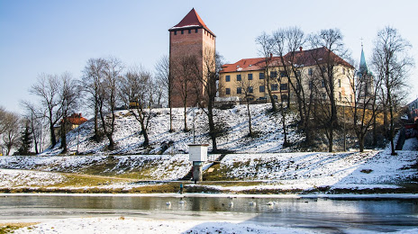
Muzeum Zamek w Oświęcimiu — local attraction, which is located at Zamkowa 1, 32-600 Oświęcim, Poland and belongs to the category — castle. Average visitor rating for this place — 4.5 (according to 505 ratings, information from open sources and relevant for 2022).
Exact location — Muzeum Zamek w Oświęcimiu, marked on the map with a red marker.
You can get directions to Muzeum Zamek w Oświęcimiu on the map from your location.
What else is interesting in Oswiecim? You can see all the sights if you go to the city page.
Coordinates
Muzeum Zamek w Oświęcimiu, Poland coordinates in decimal format: latitude — 50.0401619087952, longitude — 19.21944439824149. When converted to degrees, minutes, seconds Muzeum Zamek w Oświęcimiu has the following coordinates: 50°2′24.58 north latitude and 19°13′10 east longitude.
Nearby cities
The largest cities that are located nearby:
- Bielsko-Biala — 26 km
- Katowice — 29 km
- Sosnowiec — 29 km
- Dabrowa Gornicza — 32 km
- Chorzow — 34 km
- Ruda Slaska — 35 km
- Bytom — 40 km
- Zabrze — 44 km
- Rybnik — 48 km
- Gliwice — 48 km
- Kraków — 52 km
- Ostrava
 (Czech Republic) — 72 km
 - Częstochowa — 86 km
- Opole — 115 km
- Tarnow — 126 km
- Kielce — 135 km
- Olomouc (Czech Republic) — 149 km
- Łódź — 191 km
- Wrocław — 192 km
Distance to the capital
Distance to the capital (Warsaw) is about — 274 km.