
 Józefów nad Wisłą
Gorzyce Wielkie
Rogówek
Sromowce Niżne
Wyszków County
Kruszewo
Jantar
Sady Górne
Nagoszewo
Józefów nad Wisłą
Gorzyce Wielkie
Rogówek
Sromowce Niżne
Wyszków County
Kruszewo
Jantar
Sady Górne
Nagoszewo
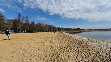
Plaża miejska w Zieleniewie on the map, Stargard Szczecinski, Poland
Photo
Where is located Plaża miejska w Zieleniewie
Plaża miejska w Zieleniewie — local attraction, which is located at no data and belongs to the category — -. Average visitor rating for this place — 4.3 (according to 69 ratings, information from open sources and relevant for 2022).
Exact location — Plaża miejska w Zieleniewie, marked on the map with a red marker.
You can get directions to Plaża miejska w Zieleniewie on the map from your location.
What else is interesting in Stargard Szczecinski? You can see all the sights if you go to the city page.
Coordinates
Plaża miejska w Zieleniewie, Poland coordinates in decimal format: latitude — 53.34878375751348, longitude — 14.92651989820507. When converted to degrees, minutes, seconds Plaża miejska w Zieleniewie has the following coordinates: 53°20′55.62 north latitude and 14°55′35.47 east longitude.
Nearby cities
The largest cities that are located nearby:
- Szczecin — 34 km
- Gorzów Wielkopolski — 68 km
- Koszalin — 119 km
- Berlin
 (Germany) — 143 km
 - Berlin (Germany) — 145 km
- Zielona Gora — 158 km
- Poznań — 163 km
- Potsdam (Germany) — 170 km
- Cottbus (Germany) — 181 km
- Bydgoszcz — 198 km
- Rostock (Germany) — 209 km
- Torun — 239 km
- Legnica — 248 km
- Gdańsk — 258 km
- Gdynia — 259 km
- Magdeburg (Germany) — 268 km
- Dresden (Germany) — 269 km
- Kalisz — 271 km
- Wloclawek — 280 km
Distance to the capital
Distance to the capital (Warsaw) is about — 428 km.