
 Puerto de la Duquesa
La Serna de Iguña
Pumalverde
Puentenansa
La Iglesia
Casar de Periedo
Fuengirola
Renedo de Piélagos
Villabanez
Puerto de la Duquesa
La Serna de Iguña
Pumalverde
Puentenansa
La Iglesia
Casar de Periedo
Fuengirola
Renedo de Piélagos
Villabanez
Estany d'Ivars i Vila-sana on the map, Mollerussa, Spain
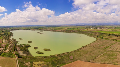
Photo
Where is located Estany d'Ivars i Vila-sana
Estany d'Ivars i Vila-sana — local attraction, which is located at Cal Sinen, Estany d'Ivars i Vil·lasana, 25260 Ivars d'Urgell, Lleida, Spain and belongs to the category — national park. Average visitor rating for this place — 4.5 (according to 1561 rating, information from open sources and relevant for 2022).
Exact location — Estany d'Ivars i Vila-sana, marked on the map with a red marker.
You can get directions to Estany d'Ivars i Vila-sana on the map from your location.
What else is interesting in Mollerussa? You can see all the sights if you go to the city page.
Coordinates
Estany d'Ivars i Vila-sana, Spain coordinates in decimal format: latitude — 41.682389515491636, longitude — 0.9477173978014937. When converted to degrees, minutes, seconds Estany d'Ivars i Vila-sana has the following coordinates: 41°40′56.6 north latitude and 0°56′51.78 east longitude.
Nearby cities
The largest cities that are located nearby:
- Lleida — 23 km
- Tarragona — 63 km
- Terrassa — 92 km
- Sabadell — 101 km
- L'Hospitalet de Llobregat — 105 km
- Santa Coloma de Gramenet — 111 km
- Badalona — 114 km
- Mataró — 129 km
- Zaragoza — 147 km
- Perpignan
 (France) — 200 km
 - Toulouse (France) — 223 km
- Pamplona — 244 km
- Valencia — 262 km
- Palma — 272 km
- Logroño — 288 km
- San Sebastián — 297 km
- Vitoria-Gasteiz — 320 km
- Montpellier (France) — 324 km
- Bilbao — 357 km
Distance to the capital
Distance to the capital (Madrid) is about — 415 km.