
 Belém
Maranguape
Paranaguá
Paranaguá
Monte Alegre
Alvorada de Minas
Bragança
Laguna
Ibiporã
Belém
Maranguape
Paranaguá
Paranaguá
Monte Alegre
Alvorada de Minas
Bragança
Laguna
Ibiporã
Iguazu Falls on the map, Foz do Iguaçu, Brazil
Photo
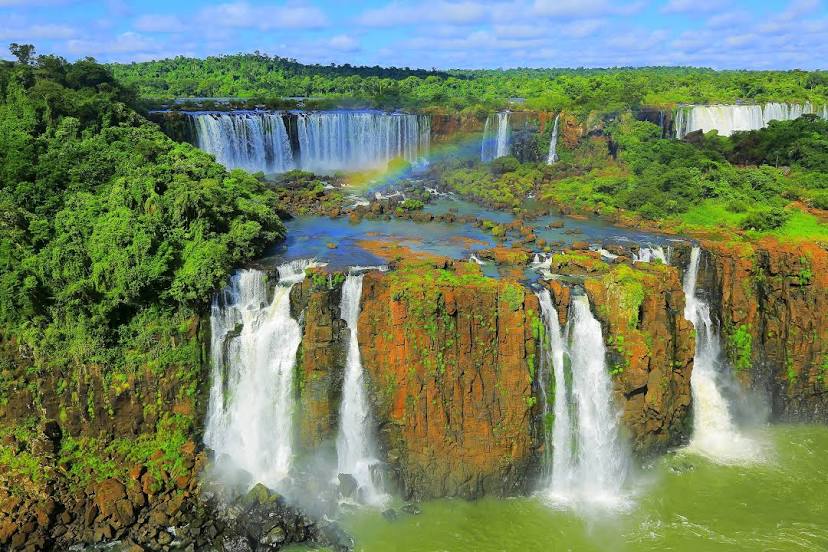
Where is located Iguazu Falls
Iguazu Falls — local attraction, which is located at Misiones Province, Argentina and belongs to the category — waterfall. Average visitor rating for this place — 4.9 (according to 71337 ratings, information from open sources and relevant for 2022).
Exact location — Iguazu Falls, marked on the map with a red marker.
You can get directions to Iguazu Falls on the map from your location.
What else is interesting in Foz do Iguaçu? You can see all the sights if you go to the city page.
Coordinates
Iguazu Falls, Brazil coordinates in decimal format: latitude — -25.518815314645774, longitude — -54.54696599987912. When converted to degrees, minutes, seconds Iguazu Falls has the following coordinates: -25°31′7.74 north latitude and -54°32′49.08 east longitude.
Nearby cities
The largest cities that are located nearby:
- Ciudad del Este
 (Paraguay) — 3 km
 - Cascavel — 129 km
- Posadas
 (Argentina) — 242 km
 - Chapecó — 261 km
- Capiata (Paraguay) — 287 km
- Luque (Paraguay) — 291 km
- San Lorenzo (Paraguay) — 294 km
- Fernando De La Mora (Paraguay) — 297 km
- Lambare (Paraguay) — 303 km
- Asuncion (Paraguay) — 306 km
- Guarapuava — 312 km
- Maringá — 355 km
- Formosa (Argentina) — 364 km
- Dourados — 365 km
- Passo Fundo — 370 km
- Apucarana — 384 km
- Santa Maria — 467 km
- Corrientes (Argentina) — 470 km
- Resistencia (Argentina) — 482 km
Distance to the capital
Distance to the capital (Asuncion) is about — 306 km.