
 Maureville
Samoëns
Gréning
Toulouse
Volx
Goudet
Méhoncourt
Saint-Hymer
Pontcarré
Maureville
Samoëns
Gréning
Toulouse
Volx
Goudet
Méhoncourt
Saint-Hymer
Pontcarré
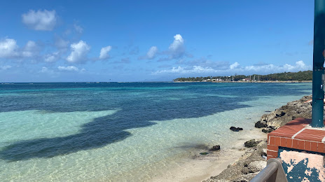
Plage de Sainte-Anne on the map, Plouzané, France
Photo
Where is located Plage de Sainte-Anne
Plage de Sainte-Anne — local attraction, which is located at no data and belongs to the category — -. Average visitor rating for this place — 4.2 (according to 47 ratings, information from open sources and relevant for 2022).
Exact location — Plage de Sainte-Anne, marked on the map with a red marker.
You can get directions to Plage de Sainte-Anne on the map from your location.
What else is interesting in Plouzané? You can see all the sights if you go to the city page.
Coordinates
Plage de Sainte-Anne, France coordinates in decimal format: latitude — 48.27194047867484, longitude — -4.483409609558537. When converted to degrees, minutes, seconds Plage de Sainte-Anne has the following coordinates: 48°16′18.99 north latitude and -4°29′0.27 east longitude.
Nearby cities
The largest cities that are located nearby:
- Brest — 10 km
- Rennes — 219 km
- Nantes — 264 km
- Exeter
 (United Kingdom) — 269 km
 - Angers — 319 km
- Caen — 320 km
- Bournemouth (United Kingdom) — 322 km
- Southampton (United Kingdom) — 358 km
- Le Mans — 359 km
- Le Havre — 361 km
- Portsmouth (United Kingdom) — 365 km
- Bristol (Great Britain) — 367 km
- Swindon (United Kingdom) — 402 km
- Tours — 412 km
- Reading (United Kingdom) — 422 km
- Cheltenham (United Kingdom) — 426 km
- Rouen — 428 km
- Crawley (United Kingdom) — 431 km
- Eastbourne (United Kingdom) — 433 km
Distance to the capital
Distance to the capital (Paris) is about — 507 km.