
 Maureville
Samoëns
Gréning
Toulouse
Volx
Goudet
Méhoncourt
Saint-Hymer
Pontcarré
Maureville
Samoëns
Gréning
Toulouse
Volx
Goudet
Méhoncourt
Saint-Hymer
Pontcarré
Park Alfred Wallach (Parc Alfred Wallach) on the map, Riedisheim, France
Photo
Where is located Park Alfred Wallach (Parc Alfred Wallach)
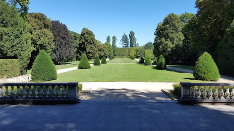
Park Alfred Wallach (Parc Alfred Wallach) — local attraction, which is located at 4 Rue des Sapins, 68400 Riedisheim, France and belongs to the category — park. Average visitor rating for this place — 4.5 (according to 842 ratings, information from open sources and relevant for 2022).
Exact location — Park Alfred Wallach (Parc Alfred Wallach), marked on the map with a red marker.
You can get directions to Park Alfred Wallach (Parc Alfred Wallach) on the map from your location.
What else is interesting in Riedisheim? You can see all the sights if you go to the city page.
Coordinates
Park Alfred Wallach (Parc Alfred Wallach), France coordinates in decimal format: latitude — 47.73746854254237, longitude — 7.3597612981600005. When converted to degrees, minutes, seconds Park Alfred Wallach (Parc Alfred Wallach) has the following coordinates: 47°44′14.89 north latitude and 7°21′35.14 east longitude.
Nearby cities
The largest cities that are located nearby:
- Mulhouse — 2 km
- Basel
 (Switzerland) — 26 km
 - Freiburg
 (Germany) — 45 km
 - Bern (Switzerland) — 89 km
- Strasbourg — 95 km
- Zurich (Switzerland) — 97 km
- Besançon — 116 km
- Nancy — 135 km
- Lausanne (Switzerland) — 147 km
- Karlsruhe (Germany) — 158 km
- Reutlingen (Germany) — 158 km
- Pforzheim (Germany) — 159 km
- Saarbrücken (Germany) — 167 km
- Stuttgart (Germany) — 174 km
- Metz — 174 km
- Dijon — 181 km
- Geneva (Switzerland) — 196 km
- Heilbronn (Germany) — 204 km
- Heidelberg (Germany) — 205 km
Distance to the capital
Distance to the capital (Paris) is about — 391 km.