
 Maureville
Samoëns
Gréning
Toulouse
Volx
Goudet
Méhoncourt
Saint-Hymer
Pontcarré
Maureville
Samoëns
Gréning
Toulouse
Volx
Goudet
Méhoncourt
Saint-Hymer
Pontcarré
Le Château des Confluences on the map, Castanet-Tolosan, France
Photo
Where is located Le Château des Confluences
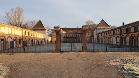
Le Château des Confluences — local attraction, which is located at Château Bertier, 31120 Pinsaguel, France and belongs to the category — castle. Average visitor rating for this place — 4.2 (according to 75 ratings, information from open sources and relevant for 2022).
Exact location — Le Château des Confluences, marked on the map with a red marker.
You can get directions to Le Château des Confluences on the map from your location.
What else is interesting in Castanet-Tolosan? You can see all the sights if you go to the city page.
Coordinates
Le Château des Confluences, France coordinates in decimal format: latitude — 43.510917633259844, longitude — 1.3955628980180532. When converted to degrees, minutes, seconds Le Château des Confluences has the following coordinates: 43°30′39.3 north latitude and 1°23′44.03 east longitude.
Nearby cities
The largest cities that are located nearby:
- Toulouse — 11 km
- Perpignan — 146 km
- Montpellier — 191 km
- Bordeaux — 219 km
- Terrassa
 (Spain) — 220 km
 - Lleida (Spain) — 222 km
- Sabadell (Spain) — 223 km
- Nimes — 231 km
- Mataró (Spain) — 232 km
- Santa Coloma de Gramenet (Spain) — 236 km
- Badalona (Spain) — 237 km
- L'Hospitalet de Llobregat (Spain) — 243 km
- Limoges — 257 km
- Tarragona (Spain) — 266 km
- Pamplona (Spain) — 267 km
- Clermont-Ferrand — 278 km
- San Sebastián (Spain) — 281 km
- Zaragoza (Spain) — 286 km
- Saint-Étienne — 309 km
Distance to the capital
Distance to the capital (Paris) is about — 599 km.