
 Belém
Maranguape
Paranaguá
Paranaguá
Monte Alegre
Alvorada de Minas
Bragança
Laguna
Ibiporã
Belém
Maranguape
Paranaguá
Paranaguá
Monte Alegre
Alvorada de Minas
Bragança
Laguna
Ibiporã
Praça da Fonte Luminosa on the map, Araraquara, Brazil
Photo
Where is located Praça da Fonte Luminosa
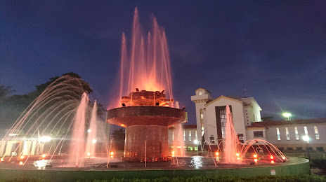
Praça da Fonte Luminosa — local attraction, which is located at R. Napoleão Selmi Dei, 26 - Vila Harmonia, Araraquara - SP, Brazil and belongs to the category — city park. Average visitor rating for this place — 4.6 (according to 984 ratings, information from open sources and relevant for 2022).
Exact location — Praça da Fonte Luminosa, marked on the map with a red marker.
You can get directions to Praça da Fonte Luminosa on the map from your location.
What else is interesting in Araraquara? You can see all the sights if you go to the city page.
Coordinates
Praça da Fonte Luminosa, Brazil coordinates in decimal format: latitude — -21.77047884063761, longitude — -48.17059100252974. When converted to degrees, minutes, seconds Praça da Fonte Luminosa has the following coordinates: -21°46′13.72 north latitude and -48°10′14.13 east longitude.
Nearby cities
The largest cities that are located nearby:
- São Carlos — 39 km
- Ribeirão Preto — 78 km
- Rio Claro — 94 km
- Araras — 104 km
- Bauru — 107 km
- Catanduva — 110 km
- Piracicaba — 118 km
- Botucatu — 125 km
- Santa Bárbara D'Oeste — 133 km
- Americana — 136 km
- Barretos — 142 km
- Sumaré — 147 km
- Hortolândia — 154 km
- Franca — 159 km
- Poços de Caldas — 166 km
- Campinas — 168 km
- Indaiatuba — 175 km
- Itu — 186 km
- Marília — 188 km