 Warner Robins
Wantagh
Bethel
Misty Hill Farm
United States
Wakonda Beach (R33) Airport
Wilmington
Poland
Miami International Airport
Warner Robins
Wantagh
Bethel
Misty Hill Farm
United States
Wakonda Beach (R33) Airport
Wilmington
Poland
Miami International Airport
Lee County Historical Society on the map, Auburn, United States
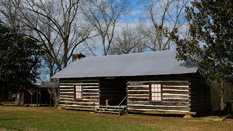
Photo
Where is located Lee County Historical Society
Lee County Historical Society — local attraction, which is located at 6500 Stage Rd, Loachapoka, AL 36865, United States and belongs to the category — museum. Average visitor rating for this place — 4.7 (according to 56 ratings, information from open sources and relevant for 2022).
Exact location — Lee County Historical Society, marked on the map with a red marker.
You can get directions to Lee County Historical Society on the map from your location.
What else is interesting in Auburn? You can see all the sights if you go to the city page.
Coordinates
Lee County Historical Society, United States coordinates in decimal format: latitude — 32.60475867553029, longitude — -85.59887980229738. When converted to degrees, minutes, seconds Lee County Historical Society has the following coordinates: 32°36′17.13 north latitude and -85°35′55.97 east longitude.
Nearby cities
The largest cities that are located nearby:
- Montgomery — 81 km
- Birmingham — 158 km
- Atlanta — 161 km
- Huntsville — 255 km
- Tallahassee — 266 km
- Chattanooga — 270 km
- Mobile — 322 km
- Knoxville — 396 km
- Nashville — 410 km
- Savannah — 415 km
- Columbia — 436 km
- Jackson — 441 km
- Jacksonville — 443 km
- Gainesville — 446 km
- Clarksville — 464 km
- Memphis — 499 km
- Charlotte — 509 km
- Charleston — 516 km
- New Orleans — 529 km
Distance to the capital
Distance to the capital (Washington) is about — 1042 km.