
 Gilserberg
Berlin
Bordesholm
Bechtolsheim
Aub
Triptis
Heppenheim
Biblis
Angermünde
Gilserberg
Berlin
Bordesholm
Bechtolsheim
Aub
Triptis
Heppenheim
Biblis
Angermünde
Mittelalterliche Mikwe on the map, Erfurt, Germany
Photo
Where is located Mittelalterliche Mikwe
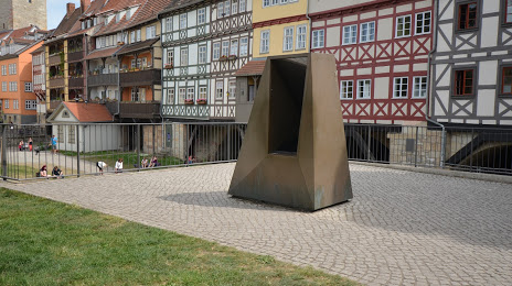
Mittelalterliche Mikwe — local attraction, which is located at Krämerbrücke 7, 99084 Erfurt, Germany and belongs to the category — historical place. Average visitor rating for this place — 4.5 (according to 39 ratings, information from open sources and relevant for 2022).
Exact location — Mittelalterliche Mikwe, marked on the map with a red marker.
You can get directions to Mittelalterliche Mikwe on the map from your location.
What else is interesting in Erfurt? You can see all the sights if you go to the city page.
Coordinates
Mittelalterliche Mikwe, Germany coordinates in decimal format: latitude — 50.97881088058387, longitude — 11.030568459739946. When converted to degrees, minutes, seconds Mittelalterliche Mikwe has the following coordinates: 50°58′43.72 north latitude and 11°1′50.05 east longitude.
Nearby cities
The largest cities that are located nearby:
- Gera — 74 km
- Göttingen — 98 km
- Leipzig — 101 km
- Kassel — 113 km
- Magdeburg — 132 km
- Chemnitz — 133 km
- Salzgitter — 137 km
- Brunswick — 146 km
- Hildesheim — 148 km
- Würzburg — 153 km
- Erlangen — 154 km
- Wolfsburg — 160 km
- Fürth — 167 km
- Nuremberg — 169 km
- Paderborn — 176 km
- Hanover — 177 km
- Offenbach — 188 km
- Dresden — 188 km
- Frankfurt — 192 km
Distance to the capital
Distance to the capital (Berlin) is about — 237 km.