
 Gilserberg
Berlin
Bordesholm
Bechtolsheim
Aub
Triptis
Heppenheim
Biblis
Angermünde
Gilserberg
Berlin
Bordesholm
Bechtolsheim
Aub
Triptis
Heppenheim
Biblis
Angermünde
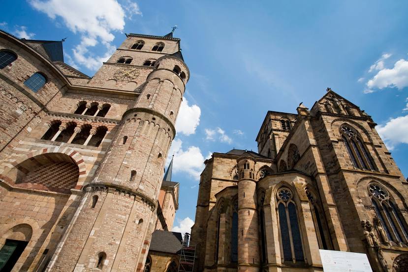
Liebfrauenkirche, Trier (Kleine Basilika/Liebfrauenkirche) on the map, Trier, Germany
Photo
Where is located Liebfrauenkirche, Trier (Kleine Basilika/Liebfrauenkirche)
Liebfrauenkirche, Trier (Kleine Basilika/Liebfrauenkirche) — local attraction, which is located at Liebfrauenstraße 2, 54290 Trier, Germany and belongs to the category — catholic church. Average visitor rating for this place — 4.7 (according to 791 rating, information from open sources and relevant for 2022).
Exact location — Liebfrauenkirche, Trier (Kleine Basilika/Liebfrauenkirche), marked on the map with a red marker.
You can get directions to Liebfrauenkirche, Trier (Kleine Basilika/Liebfrauenkirche) on the map from your location.
What else is interesting in Trier? You can see all the sights if you go to the city page.
Coordinates
Liebfrauenkirche, Trier (Kleine Basilika/Liebfrauenkirche), Germany coordinates in decimal format: latitude — 49.755746952848924, longitude — 6.643245359695645. When converted to degrees, minutes, seconds Liebfrauenkirche, Trier (Kleine Basilika/Liebfrauenkirche) has the following coordinates: 49°45′20.69 north latitude and 6°38′35.68 east longitude.
Nearby cities
The largest cities that are located nearby:
- Saarbrücken — 62 km
- Metz
 (France) — 77 km
 - Koblenz — 95 km
- Bonn — 114 km
- Mainz — 118 km
- Wiesbaden — 119 km
- Aachen — 120 km
- Nancy (France) — 122 km
- Liège
 (Belgium) — 123 km
 - Cologne — 133 km
- Ludwigshafen — 133 km
- Mannheim — 135 km
- Maastricht
 (Netherlands) — 139 km
 - Bergisch Gladbach — 142 km
- Darmstadt — 144 km
- Namur (Belgium) — 147 km
- Frankfurt — 150 km
- Heidelberg — 152 km
- Karlsruhe — 152 km
Distance to the capital
Distance to the capital (Berlin) is about — 563 km.