
 Gilserberg
Berlin
Bordesholm
Bechtolsheim
Aub
Triptis
Heppenheim
Biblis
Angermünde
Gilserberg
Berlin
Bordesholm
Bechtolsheim
Aub
Triptis
Heppenheim
Biblis
Angermünde
Lienewitz-Caputher Seen- und Feuchtgebietskette on the map, Werder, Germany
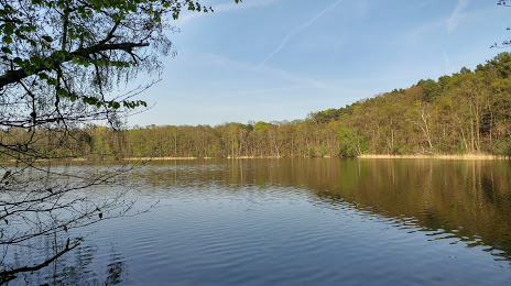
Photo
Where is located Lienewitz-Caputher Seen- und Feuchtgebietskette
Lienewitz-Caputher Seen- und Feuchtgebietskette — local attraction, which is located at Germany and belongs to the category — national reserve. Average visitor rating for this place — 4.4 (according to 66 ratings, information from open sources and relevant for 2022).
Exact location — Lienewitz-Caputher Seen- und Feuchtgebietskette, marked on the map with a red marker.
You can get directions to Lienewitz-Caputher Seen- und Feuchtgebietskette on the map from your location.
What else is interesting in Werder? You can see all the sights if you go to the city page.
Coordinates
Lienewitz-Caputher Seen- und Feuchtgebietskette, Germany coordinates in decimal format: latitude — 52.31716021136086, longitude — 12.981354259789248. When converted to degrees, minutes, seconds Lienewitz-Caputher Seen- und Feuchtgebietskette has the following coordinates: 52°19′1.78 north latitude and 12°58′52.88 east longitude.
Nearby cities
The largest cities that are located nearby:
- Potsdam — 9 km
- Berlin — 34 km
- Magdeburg — 93 km
- Cottbus — 118 km
- Leipzig — 121 km
- Wolfsburg — 145 km
- Dresden — 157 km
- Szczecin
 (Poland) — 158 km
 - Gorzów Wielkopolski (Poland) — 159 km
- Brunswick — 163 km
- Chemnitz — 171 km
- Gera — 175 km
- Salzgitter — 178 km
- Zielona Gora (Poland) — 182 km
- Rostock — 197 km
- Erfurt — 203 km
- Hildesheim — 203 km
- Hanover — 216 km
- Göttingen — 227 km
Distance to the capital
Distance to the capital (Berlin) is about — 37 km.