
 Gilserberg
Berlin
Bordesholm
Bechtolsheim
Aub
Triptis
Heppenheim
Biblis
Angermünde
Gilserberg
Berlin
Bordesholm
Bechtolsheim
Aub
Triptis
Heppenheim
Biblis
Angermünde
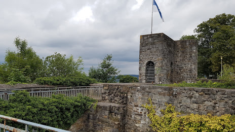
Schlossruine Arnsberg - Portal on the map, Arnsberg, Germany
Photo
Where is located Schlossruine Arnsberg - Portal
Schlossruine Arnsberg - Portal — local attraction, which is located at Schloßstraße 99, 59821 Arnsberg, Germany and belongs to the category — historical landmark. Average visitor rating for this place — 4.3 (according to 616 ratings, information from open sources and relevant for 2022).
Exact location — Schlossruine Arnsberg - Portal, marked on the map with a red marker.
You can get directions to Schlossruine Arnsberg - Portal on the map from your location.
What else is interesting in Arnsberg? You can see all the sights if you go to the city page.
Coordinates
Schlossruine Arnsberg - Portal, Germany coordinates in decimal format: latitude — 51.40095221256508, longitude — 8.062146259755389. When converted to degrees, minutes, seconds Schlossruine Arnsberg - Portal has the following coordinates: 51°24′3.43 north latitude and 8°3′43.73 east longitude.
Nearby cities
The largest cities that are located nearby:
- Hamm — 34 km
- Hagen — 41 km
- Dortmund — 42 km
- Witten — 48 km
- Siegen — 58 km
- Bochum — 58 km
- Paderborn — 59 km
- Herne — 60 km
- Recklinghausen — 63 km
- Wuppertal — 65 km
- Remscheid — 65 km
- Gelsenkirchen — 68 km
- Münster — 68 km
- Essen — 72 km
- Solingen — 72 km
- Bielefeld — 76 km
- Bottrop — 77 km
- Bergisch Gladbach — 79 km
- Mülheim — 81 km
Distance to the capital
Distance to the capital (Berlin) is about — 387 km.