
 Gilserberg
Berlin
Bordesholm
Bechtolsheim
Aub
Triptis
Heppenheim
Biblis
Angermünde
Gilserberg
Berlin
Bordesholm
Bechtolsheim
Aub
Triptis
Heppenheim
Biblis
Angermünde
Von-Velen-Anlage on the map, Papenburg, Germany
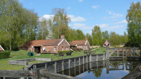
Photo
Where is located Von-Velen-Anlage
Von-Velen-Anlage — local attraction, which is located at Splitting links, 26871 Papenburg, Germany and belongs to the category — local history museum. Average visitor rating for this place — 4.6 (according to 245 ratings, information from open sources and relevant for 2022).
Exact location — Von-Velen-Anlage, marked on the map with a red marker.
You can get directions to Von-Velen-Anlage on the map from your location.
What else is interesting in Papenburg? You can see all the sights if you go to the city page.
Coordinates
Von-Velen-Anlage, Germany coordinates in decimal format: latitude — 53.06893495089706, longitude — 7.445925959817377. When converted to degrees, minutes, seconds Von-Velen-Anlage has the following coordinates: 53°4′8.17 north latitude and 7°26′45.33 east longitude.
Nearby cities
The largest cities that are located nearby:
- Emmen
 (Netherlands) — 47 km
 - Groningen (Netherlands) — 59 km
- Bremen — 92 km
- Bremerhaven — 92 km
- Osnabrück — 97 km
- Enschede (Netherlands) — 101 km
- Zwolle (Netherlands) — 109 km
- Münster — 124 km
- Apeldoorn (Netherlands) — 137 km
- Bielefeld — 138 km
- Hamm — 157 km
- Arnhem (Netherlands) — 159 km
- Recklinghausen — 162 km
- Ede (Netherlands) — 165 km
- Almere (Netherlands) — 166 km
- Herne — 170 km
- Amersfoort (Netherlands) — 171 km
- Dortmund — 172 km
- Gelsenkirchen — 173 km
Distance to the capital
Distance to the capital (Berlin) is about — 405 km.