
 Gilserberg
Berlin
Bordesholm
Bechtolsheim
Aub
Triptis
Heppenheim
Biblis
Angermünde
Gilserberg
Berlin
Bordesholm
Bechtolsheim
Aub
Triptis
Heppenheim
Biblis
Angermünde
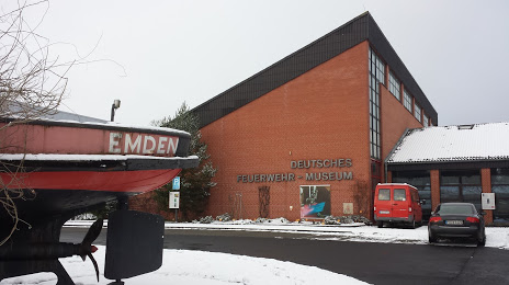
Deutsches Feuerwehr-Museum on the map, Fulda, Germany
Photo
Where is located Deutsches Feuerwehr-Museum
Deutsches Feuerwehr-Museum — local attraction, which is located at St.-Laurentius-Straße 3, 36041 Fulda, Germany and belongs to the category — museum. Average visitor rating for this place — 4.5 (according to 437 ratings, information from open sources and relevant for 2022).
Exact location — Deutsches Feuerwehr-Museum, marked on the map with a red marker.
You can get directions to Deutsches Feuerwehr-Museum on the map from your location.
What else is interesting in Fulda? You can see all the sights if you go to the city page.
Coordinates
Deutsches Feuerwehr-Museum, Germany coordinates in decimal format: latitude — 50.54543362344586, longitude — 9.665201759724175. When converted to degrees, minutes, seconds Deutsches Feuerwehr-Museum has the following coordinates: 50°32′43.56 north latitude and 9°39′54.73 east longitude.
Nearby cities
The largest cities that are located nearby:
- Offenbach — 82 km
- Kassel — 85 km
- Frankfurt — 86 km
- Würzburg — 87 km
- Erfurt — 105 km
- Darmstadt — 105 km
- Göttingen — 110 km
- Wiesbaden — 115 km
- Mainz — 119 km
- Siegen — 121 km
- Erlangen — 143 km
- Paderborn — 143 km
- Mannheim — 147 km
- Heidelberg — 147 km
- Ludwigshafen — 149 km
- Koblenz — 149 km
- Fürth — 152 km
- Nuremberg — 158 km
- Heilbronn — 160 km
Distance to the capital
Distance to the capital (Berlin) is about — 339 km.