
 Gilserberg
Berlin
Bordesholm
Bechtolsheim
Aub
Triptis
Heppenheim
Biblis
Angermünde
Gilserberg
Berlin
Bordesholm
Bechtolsheim
Aub
Triptis
Heppenheim
Biblis
Angermünde
Landscape Park Hachinger Valley on the map, Haar, Germany
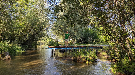
Photo
Where is located Landscape Park Hachinger Valley
Landscape Park Hachinger Valley — local attraction, which is located at An der Hachinger Haid, 82008 Unterhaching, Germany and belongs to the category — park. Average visitor rating for this place — 4.6 (according to 1006 ratings, information from open sources and relevant for 2022).
Exact location — Landscape Park Hachinger Valley, marked on the map with a red marker.
You can get directions to Landscape Park Hachinger Valley on the map from your location.
What else is interesting in Haar? You can see all the sights if you go to the city page.
Coordinates
Landscape Park Hachinger Valley, Germany coordinates in decimal format: latitude — 48.07153699877776, longitude — 11.638628159636015. When converted to degrees, minutes, seconds Landscape Park Hachinger Valley has the following coordinates: 48°4′17.53 north latitude and 11°38′19.06 east longitude.
Nearby cities
The largest cities that are located nearby:
- Munich — 11 km
- Augsburg — 68 km
- Ingolstadt — 76 km
- Innsbruck
 (Austria) — 96 km
 - Regensburg — 103 km
- Salzburg (Austria) — 104 km
- Ulm — 132 km
- Nuremberg — 156 km
- Fürth — 160 km
- Erlangen — 172 km
- Linz (Austria) — 189 km
- Reutlingen — 190 km
- Stuttgart — 200 km
- Pilsen
 (Czech Republic) — 215 km
 - Heilbronn — 215 km
- Würzburg — 225 km
- Trento
 (Italy) — 230 km
 - Pforzheim — 237 km
- Zurich
 (Switzerland) — 253 km
Distance to the capital
Distance to the capital (Berlin) is about — 510 km.