
 Gilserberg
Berlin
Bordesholm
Bechtolsheim
Aub
Triptis
Heppenheim
Biblis
Angermünde
Gilserberg
Berlin
Bordesholm
Bechtolsheim
Aub
Triptis
Heppenheim
Biblis
Angermünde
Sieben-Täler-Höhle on the map, Böblingen, Germany
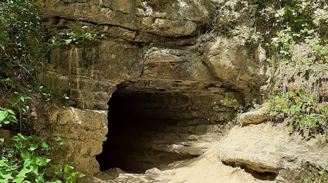
Photo
Where is located Sieben-Täler-Höhle
Sieben-Täler-Höhle — local attraction, which is located at Unnamed Road, 72108, 72108 Rottenburg am Neckar, Germany and belongs to the category — tourist attraction. Average visitor rating for this place — 4.4 (according to 34 ratings, information from open sources and relevant for 2022).
Exact location — Sieben-Täler-Höhle, marked on the map with a red marker.
You can get directions to Sieben-Täler-Höhle on the map from your location.
What else is interesting in Böblingen? You can see all the sights if you go to the city page.
Coordinates
Sieben-Täler-Höhle, Germany coordinates in decimal format: latitude — 48.44258843565206, longitude — 8.905859659649053. When converted to degrees, minutes, seconds Sieben-Täler-Höhle has the following coordinates: 48°26′33.32 north latitude and 8°54′21.09 east longitude.
Nearby cities
The largest cities that are located nearby:
- Stuttgart — 16 km
- Reutlingen — 24 km
- Pforzheim — 33 km
- Heilbronn — 53 km
- Karlsruhe — 57 km
- Ulm — 78 km
- Heidelberg — 83 km
- Strasbourg
 (France) — 93 km
 - Ludwigshafen — 97 km
- Mannheim — 97 km
- Freiburg — 115 km
- Darmstadt — 134 km
- Würzburg — 140 km
- Augsburg — 143 km
- Zurich
 (Switzerland) — 149 km
 - Mainz — 155 km
- Offenbach — 157 km
- Saarbrücken — 158 km
- Frankfurt — 160 km
Distance to the capital
Distance to the capital (Berlin) is about — 554 km.