
 Gilserberg
Berlin
Bordesholm
Bechtolsheim
Aub
Triptis
Heppenheim
Biblis
Angermünde
Gilserberg
Berlin
Bordesholm
Bechtolsheim
Aub
Triptis
Heppenheim
Biblis
Angermünde
Church of Saint Michael in Eutin on the map, Eutin, Germany
Photo
Where is located Church of Saint Michael in Eutin
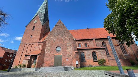
Church of Saint Michael in Eutin — local attraction, which is located at Schloßstraße 2, 23701 Eutin, Germany and belongs to the category — protestant church. Average visitor rating for this place — 4.4 (according to 21 rating, information from open sources and relevant for 2022).
Exact location — Church of Saint Michael in Eutin, marked on the map with a red marker.
You can get directions to Church of Saint Michael in Eutin on the map from your location.
What else is interesting in Eutin? You can see all the sights if you go to the city page.
Coordinates
Church of Saint Michael in Eutin, Germany coordinates in decimal format: latitude — 54.13738477192747, longitude — 10.617328859857754. When converted to degrees, minutes, seconds Church of Saint Michael in Eutin has the following coordinates: 54°8′14.59 north latitude and 10°37′2.38 east longitude.
Nearby cities
The largest cities that are located nearby:
- Kiel — 38 km
- Rostock — 97 km
- Odense
 (Denmark) — 141 km
 - Bremerhaven — 149 km
- Bremen — 167 km
- Wolfsburg — 189 km
- Hanover — 203 km
- Brunswick — 206 km
- Copenhagen (Denmark) — 210 km
- Salzgitter — 220 km
- Malmö
 (Sweden) — 221 km
 - Hildesheim — 223 km
- Aarhus (Denmark) — 226 km
- Magdeburg — 233 km
- Potsdam — 254 km
- Berlin — 260 km
- Osnabrück — 268 km
- Szczecin
 (Poland) — 271 km
 - Bielefeld — 272 km
Distance to the capital
Distance to the capital (Berlin) is about — 258 km.