
 Gilserberg
Berlin
Bordesholm
Bechtolsheim
Aub
Triptis
Heppenheim
Biblis
Angermünde
Gilserberg
Berlin
Bordesholm
Bechtolsheim
Aub
Triptis
Heppenheim
Biblis
Angermünde
Botanischer Garten Chemnitz on the map, Chemnitz, Germany
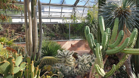
Photo
Where is located Botanischer Garten Chemnitz
Botanischer Garten Chemnitz — local attraction, which is located at Leipziger Str. 147, 09114 Chemnitz, Germany and belongs to the category — botanical garden. Average visitor rating for this place — 4.6 (according to 987 ratings, information from open sources and relevant for 2022).
Exact location — Botanischer Garten Chemnitz, marked on the map with a red marker.
You can get directions to Botanischer Garten Chemnitz on the map from your location.
What else is interesting in Chemnitz? You can see all the sights if you go to the city page.
Coordinates
Botanischer Garten Chemnitz, Germany coordinates in decimal format: latitude — 50.84993930594283, longitude — 12.890720359735246. When converted to degrees, minutes, seconds Botanischer Garten Chemnitz has the following coordinates: 50°50′59.78 north latitude and 12°53′26.59 east longitude.
Nearby cities
The largest cities that are located nearby:
- Gera — 59 km
- Dresden — 62 km
- Leipzig — 68 km
- Pilsen
 (Czech Republic) — 125 km
 - Erfurt — 133 km
- Prague (Czech Republic) — 136 km
- Cottbus — 141 km
- Magdeburg — 168 km
- Potsdam — 173 km
- Berlin — 187 km
- Erlangen — 194 km
- Nuremberg — 202 km
- Fürth — 204 km
- Regensburg — 209 km
- Zielona Gora
 (Poland) — 215 km
 - Göttingen — 221 km
- Brunswick — 227 km
- Wolfsburg — 228 km
- Legnica (Poland) — 228 km
Distance to the capital
Distance to the capital (Berlin) is about — 189 km.