
 Gilserberg
Berlin
Bordesholm
Bechtolsheim
Aub
Triptis
Heppenheim
Biblis
Angermünde
Gilserberg
Berlin
Bordesholm
Bechtolsheim
Aub
Triptis
Heppenheim
Biblis
Angermünde
Römerpark / Römerkastell on the map, Eislingen, Germany
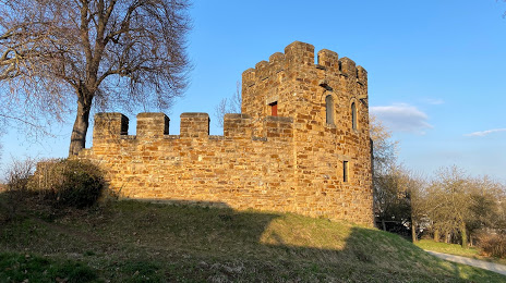
Photo
Where is located Römerpark / Römerkastell
Römerpark / Römerkastell — local attraction, which is located at Beethovenstraße 11, 73257 Köngen, Germany and belongs to the category — historical place. Average visitor rating for this place — 4.4 (according to 128 ratings, information from open sources and relevant for 2022).
Exact location — Römerpark / Römerkastell, marked on the map with a red marker.
You can get directions to Römerpark / Römerkastell on the map from your location.
What else is interesting in Eislingen? You can see all the sights if you go to the city page.
Coordinates
Römerpark / Römerkastell, Germany coordinates in decimal format: latitude — 48.67733319471542, longitude — 9.359606659657286. When converted to degrees, minutes, seconds Römerpark / Römerkastell has the following coordinates: 48°40′38.4 north latitude and 9°21′34.58 east longitude.
Nearby cities
The largest cities that are located nearby:
- Ulm — 38 km
- Stuttgart — 39 km
- Reutlingen — 42 km
- Heilbronn — 61 km
- Pforzheim — 77 km
- Augsburg — 94 km
- Karlsruhe — 101 km
- Heidelberg — 108 km
- Würzburg — 123 km
- Mannheim — 125 km
- Ludwigshafen — 125 km
- Ingolstadt — 126 km
- Fürth — 126 km
- Nuremberg — 129 km
- Erlangen — 136 km
- Strasbourg
 (France) — 144 km
 - Darmstadt — 151 km
- Munich — 152 km
- Freiburg — 158 km
Distance to the capital
Distance to the capital (Berlin) is about — 514 km.