
 Gilserberg
Berlin
Bordesholm
Bechtolsheim
Aub
Triptis
Heppenheim
Biblis
Angermünde
Gilserberg
Berlin
Bordesholm
Bechtolsheim
Aub
Triptis
Heppenheim
Biblis
Angermünde
Abtei Rommersdorf-Stiftung on the map, Neuwied, Germany
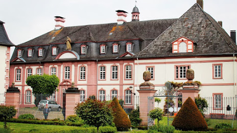
Photo
Where is located Abtei Rommersdorf-Stiftung
Abtei Rommersdorf-Stiftung — local attraction, which is located at Stiftsstraße 2, 56566 Neuwied, Germany and belongs to the category — foundation. Average visitor rating for this place — 4.5 (according to 141 rating, information from open sources and relevant for 2022).
Exact location — Abtei Rommersdorf-Stiftung, marked on the map with a red marker.
You can get directions to Abtei Rommersdorf-Stiftung on the map from your location.
What else is interesting in Neuwied? You can see all the sights if you go to the city page.
Coordinates
Abtei Rommersdorf-Stiftung, Germany coordinates in decimal format: latitude — 50.456383366093974, longitude — 7.537641659720958. When converted to degrees, minutes, seconds Abtei Rommersdorf-Stiftung has the following coordinates: 50°27′22.98 north latitude and 7°32′15.51 east longitude.
Nearby cities
The largest cities that are located nearby:
- Koblenz — 12 km
- Bonn — 42 km
- Siegen — 63 km
- Cologne — 66 km
- Bergisch Gladbach — 66 km
- Wiesbaden — 68 km
- Mainz — 74 km
- Remscheid — 84 km
- Solingen — 85 km
- Wuppertal — 93 km
- Frankfurt — 93 km
- Trier — 96 km
- Düsseldorf — 100 km
- Offenbach — 100 km
- Neuss — 101 km
- Hagen — 103 km
- Aachen — 104 km
- Darmstadt — 105 km
- Mönchengladbach — 109 km
Distance to the capital
Distance to the capital (Berlin) is about — 466 km.