
 Puerto de la Duquesa
La Serna de Iguña
Pumalverde
Puentenansa
La Iglesia
Casar de Periedo
Fuengirola
Renedo de Piélagos
Villabanez
Puerto de la Duquesa
La Serna de Iguña
Pumalverde
Puentenansa
La Iglesia
Casar de Periedo
Fuengirola
Renedo de Piélagos
Villabanez
Parque de Mataleñas on the map, Santander, Spain
Photo
Where is located Parque de Mataleñas
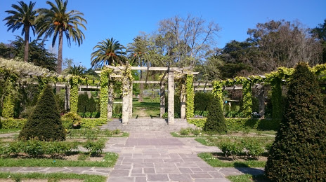
Parque de Mataleñas — local attraction, which is located at Av. del Faro, 12, 39012 Santander, Cantabria, Spain and belongs to the category — park. Average visitor rating for this place — 4.7 (according to 1911 ratings, information from open sources and relevant for 2022).
Exact location — Parque de Mataleñas, marked on the map with a red marker.
You can get directions to Parque de Mataleñas on the map from your location.
What else is interesting in Santander? You can see all the sights if you go to the city page.
Coordinates
Parque de Mataleñas, Spain coordinates in decimal format: latitude — 43.48316468748327, longitude — -3.7861653405184272. When converted to degrees, minutes, seconds Parque de Mataleñas has the following coordinates: 43°28′59.39 north latitude and -3°47′10.2 east longitude.
Nearby cities
The largest cities that are located nearby:
- Bilbao — 74 km
- Vitoria-Gasteiz — 113 km
- Burgos — 124 km
- San Sebastián — 148 km
- Gijón — 149 km
- Logroño — 157 km
- Oviedo — 164 km
- León — 172 km
- Pamplona — 190 km
- Valladolid — 214 km
- Bordeaux
 (France) — 295 km
 - Zaragoza — 314 km
- Salamanca — 316 km
- Alcobendas — 324 km
- Alcala de Henares — 332 km
- Torrejón de Ardoz — 333 km
- Alcorcón — 344 km
- Leganés — 346 km
- Móstoles — 347 km
Distance to the capital
Distance to the capital (Madrid) is about — 341 km.