
 Józefów nad Wisłą
Gorzyce Wielkie
Rogówek
Sromowce Niżne
Wyszków County
Kruszewo
Jantar
Sady Górne
Nagoszewo
Józefów nad Wisłą
Gorzyce Wielkie
Rogówek
Sromowce Niżne
Wyszków County
Kruszewo
Jantar
Sady Górne
Nagoszewo
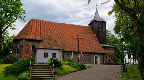
Kościół Rzymskokatolicki Pw. św. Michała Archanioła on the map, Gdynia, Poland
Photo
Where is located Kościół Rzymskokatolicki Pw. św. Michała Archanioła
Kościół Rzymskokatolicki Pw. św. Michała Archanioła — local attraction, which is located at Pułkownika Stanisława Dąbka 1, 81-107 Gdynia, Poland and belongs to the category — catholic church. Average visitor rating for this place — 4.7 (according to 152 ratings, information from open sources and relevant for 2022).
Exact location — Kościół Rzymskokatolicki Pw. św. Michała Archanioła, marked on the map with a red marker.
You can get directions to Kościół Rzymskokatolicki Pw. św. Michała Archanioła on the map from your location.
What else is interesting in Gdynia? You can see all the sights if you go to the city page.
Coordinates
Kościół Rzymskokatolicki Pw. św. Michała Archanioła, Poland coordinates in decimal format: latitude — 54.54718697643776, longitude — 18.55208902543346. When converted to degrees, minutes, seconds Kościół Rzymskokatolicki Pw. św. Michała Archanioła has the following coordinates: 54°32′49.87 north latitude and 18°33′7.52 east longitude.
Nearby cities
The largest cities that are located nearby:
- Gdańsk — 20 km
- Elblag — 69 km
- Kaliningrad
 (Russia) — 129 km
 - Olsztyn — 151 km
- Koszalin — 157 km
- Bydgoszcz — 158 km
- Torun — 166 km
- Klaipėda
 (Lithuania) — 209 km
 - Wloclawek — 210 km
- Plock — 232 km
- Poznań — 257 km
- Szczecin — 288 km
- Gorzów Wielkopolski — 296 km
- Kalisz — 306 km
- Łódź — 312 km
- Šiauliai (Lithuania) — 335 km
- Bialystok — 344 km
- Kaunas (Lithuania) — 344 km
- Zielona Gora — 352 km
Distance to the capital
Distance to the capital (Warsaw) is about — 305 km.