
 Józefów nad Wisłą
Gorzyce Wielkie
Rogówek
Sromowce Niżne
Wyszków County
Kruszewo
Jantar
Sady Górne
Nagoszewo
Józefów nad Wisłą
Gorzyce Wielkie
Rogówek
Sromowce Niżne
Wyszków County
Kruszewo
Jantar
Sady Górne
Nagoszewo
Muzeum Miasta Ostrowa Wielkopolskiego on the map, Ostrow Wielkopolski, Poland
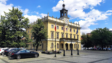
Photo
Where is located Muzeum Miasta Ostrowa Wielkopolskiego
Muzeum Miasta Ostrowa Wielkopolskiego — local attraction, which is located at Rynek 1, 63-400 Ostrów Wielkopolski, Poland and belongs to the category — museum. Average visitor rating for this place — 4.6 (according to 150 ratings, information from open sources and relevant for 2022).
Exact location — Muzeum Miasta Ostrowa Wielkopolskiego, marked on the map with a red marker.
You can get directions to Muzeum Miasta Ostrowa Wielkopolskiego on the map from your location.
What else is interesting in Ostrow Wielkopolski? You can see all the sights if you go to the city page.
Coordinates
Muzeum Miasta Ostrowa Wielkopolskiego, Poland coordinates in decimal format: latitude — 51.64958792355974, longitude — 17.816704725324676. When converted to degrees, minutes, seconds Muzeum Miasta Ostrowa Wielkopolskiego has the following coordinates: 51°38′58.52 north latitude and 17°49′0.14 east longitude.
Nearby cities
The largest cities that are located nearby:
- Kalisz — 23 km
- Wrocław — 81 km
- Poznań — 102 km
- Opole — 109 km
- Łódź — 113 km
- Legnica — 125 km
- Częstochowa — 131 km
- Wloclawek — 139 km
- Walbrzych — 144 km
- Torun — 159 km
- Zielona Gora — 160 km
- Plock — 161 km
- Gliwice — 162 km
- Zabrze — 162 km
- Bydgoszcz — 163 km
- Bytom — 164 km
- Chorzow — 171 km
- Ruda Slaska — 172 km
- Katowice — 176 km
Distance to the capital
Distance to the capital (Warsaw) is about — 228 km.