
 Gilserberg
Berlin
Bordesholm
Bechtolsheim
Aub
Triptis
Heppenheim
Biblis
Angermünde
Gilserberg
Berlin
Bordesholm
Bechtolsheim
Aub
Triptis
Heppenheim
Biblis
Angermünde
St. Pauls-Gemeinde Gemeindebüro on the map, Schwerin, Germany
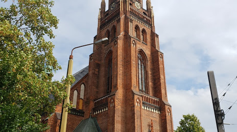
Photo
Where is located St. Pauls-Gemeinde Gemeindebüro
St. Pauls-Gemeinde Gemeindebüro — local attraction, which is located at Am Packhof 8, 19053 Schwerin, Germany and belongs to the category — evangelical church. Average visitor rating for this place — 4.6 (according to 74 ratings, information from open sources and relevant for 2022).
Exact location — St. Pauls-Gemeinde Gemeindebüro, marked on the map with a red marker.
You can get directions to St. Pauls-Gemeinde Gemeindebüro on the map from your location.
What else is interesting in Schwerin? You can see all the sights if you go to the city page.
Coordinates
St. Pauls-Gemeinde Gemeindebüro, Germany coordinates in decimal format: latitude — 53.631521351310546, longitude — 11.408249325398643. When converted to degrees, minutes, seconds St. Pauls-Gemeinde Gemeindebüro has the following coordinates: 53°37′53.48 north latitude and 11°24′29.7 east longitude.
Nearby cities
The largest cities that are located nearby:
- Rostock — 68 km
- Kiel — 112 km
- Wolfsburg — 140 km
- Brunswick — 162 km
- Magdeburg — 168 km
- Potsdam — 178 km
- Hanover — 179 km
- Salzgitter — 180 km
- Bremen — 183 km
- Berlin — 184 km
- Bremerhaven — 186 km
- Hildesheim — 191 km
- Odense
 (Denmark) — 205 km
 - Szczecin
 (Poland) — 209 km
 - Copenhagen (Denmark) — 237 km
- Malmö
 (Sweden) — 240 km
 - Göttingen — 253 km
- Leipzig — 263 km
- Bielefeld — 264 km
Distance to the capital
Distance to the capital (Berlin) is about — 182 km.