
 Puerto de la Duquesa
La Serna de Iguña
Pumalverde
Puentenansa
La Iglesia
Casar de Periedo
Fuengirola
Renedo de Piélagos
Villabanez
Puerto de la Duquesa
La Serna de Iguña
Pumalverde
Puentenansa
La Iglesia
Casar de Periedo
Fuengirola
Renedo de Piélagos
Villabanez
La Casa del Belén on the map, Murcia, Spain
Photo
Where is located La Casa del Belén
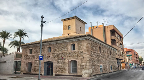
La Casa del Belén — local attraction, which is located at Calle Olivo esquina con Travesía Torre 2, s/n, 30006 Puente Tocinos, Murcia, Spain and belongs to the category — museum. Average visitor rating for this place — 4.2 (according to 53 ratings, information from open sources and relevant for 2022).
Exact location — La Casa del Belén, marked on the map with a red marker.
You can get directions to La Casa del Belén on the map from your location.
What else is interesting in Murcia? You can see all the sights if you go to the city page.
Coordinates
La Casa del Belén, Spain coordinates in decimal format: latitude — 37.99203473062749, longitude — -1.1004869751266642. When converted to degrees, minutes, seconds La Casa del Belén has the following coordinates: 37°59′31.33 north latitude and -1°6′1.75 east longitude.
Nearby cities
The largest cities that are located nearby:
- Cartagena — 42 km
- Albacete — 127 km
- Almería — 174 km
- Valencia — 176 km
- Jaén — 233 km
- Granada — 235 km
- Oran
 (Algeria) — 258 km
 - Relizane (Algeria) — 292 km
- Chlef (Algeria) — 299 km
- Sidi Bel Abbes (Algeria) — 312 km
- Córdoba — 319 km
- Málaga — 324 km
- Alcala de Henares — 333 km
- Torrejón de Ardoz — 336 km
- Getafe — 337 km
- Fuenlabrada — 340 km
- Leganés — 341 km
- Tlemcen (Algeria) — 344 km
- Alcorcón — 346 km
Distance to the capital
Distance to the capital (Madrid) is about — 351 km.