
 Józefów nad Wisłą
Gorzyce Wielkie
Rogówek
Sromowce Niżne
Wyszków County
Kruszewo
Jantar
Sady Górne
Nagoszewo
Józefów nad Wisłą
Gorzyce Wielkie
Rogówek
Sromowce Niżne
Wyszków County
Kruszewo
Jantar
Sady Górne
Nagoszewo
Klasztorne Stawy on the map, Slupsk, Poland
Photo
Where is located Klasztorne Stawy
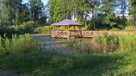
Klasztorne Stawy — local attraction, which is located at Świętej Klary z Asyżu, 76-200 Słupsk, Poland and belongs to the category — park. Average visitor rating for this place — 4.1 (according to 332 ratings, information from open sources and relevant for 2022).
Exact location — Klasztorne Stawy, marked on the map with a red marker.
You can get directions to Klasztorne Stawy on the map from your location.
What else is interesting in Slupsk? You can see all the sights if you go to the city page.
Coordinates
Klasztorne Stawy, Poland coordinates in decimal format: latitude — 54.48125948118748, longitude — 17.013477075430973. When converted to degrees, minutes, seconds Klasztorne Stawy has the following coordinates: 54°28′52.53 north latitude and 17°0′48.52 east longitude.
Nearby cities
The largest cities that are located nearby:
- Koszalin — 63 km
- Gdynia — 97 km
- Gdańsk — 105 km
- Elblag — 158 km
- Bydgoszcz — 162 km
- Torun — 191 km
- Szczecin — 199 km
- Kaliningrad
 (Russia) — 225 km
 - Gorzów Wielkopolski — 226 km
- Poznań — 228 km
- Olsztyn — 238 km
- Wloclawek — 243 km
- Plock — 278 km
- Malmö
 (Sweden) — 281 km
 - Klaipėda
 (Lithuania) — 291 km
 - Zielona Gora — 298 km
- Kalisz — 307 km
- Copenhagen
 (Denmark) — 309 km
 - Rostock
 (Germany) — 322 km
Distance to the capital
Distance to the capital (Warsaw) is about — 365 km.