
 Józefów nad Wisłą
Gorzyce Wielkie
Rogówek
Sromowce Niżne
Wyszków County
Kruszewo
Jantar
Sady Górne
Nagoszewo
Józefów nad Wisłą
Gorzyce Wielkie
Rogówek
Sromowce Niżne
Wyszków County
Kruszewo
Jantar
Sady Górne
Nagoszewo
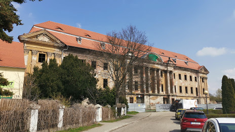
Promnitz-Palais on the map, Żary, Poland
Photo
Where is located Promnitz-Palais
Promnitz-Palais — local attraction, which is located at Zamkowa 1B, 68-200 Żary, Poland and belongs to the category — historical landmark. Average visitor rating for this place — 4.1 (according to 138 ratings, information from open sources and relevant for 2022).
Exact location — Promnitz-Palais, marked on the map with a red marker.
You can get directions to Promnitz-Palais on the map from your location.
What else is interesting in Żary? You can see all the sights if you go to the city page.
Coordinates
Promnitz-Palais, Poland coordinates in decimal format: latitude — 51.63969001701776, longitude — 15.142330625324295. When converted to degrees, minutes, seconds Promnitz-Palais has the following coordinates: 51°38′22.88 north latitude and 15°8′32.39 east longitude.
Nearby cities
The largest cities that are located nearby:
- Zielona Gora — 41 km
- Cottbus
 (Germany) — 56 km
 - Legnica — 85 km
- Dresden (Germany) — 117 km
- Gorzów Wielkopolski — 121 km
- Walbrzych — 124 km
- Wrocław — 145 km
- Poznań — 147 km
- Berlin (Germany) — 151 km
- Berlin (Germany) — 152 km
- Potsdam (Germany) — 163 km
- Chemnitz (Germany) — 179 km
- Prague
 (Czech Republic) — 180 km
 - Leipzig (Germany) — 194 km
- Szczecin — 201 km
- Kalisz — 202 km
- Opole — 222 km
- Gera (Germany) — 229 km
- Magdeburg (Germany) — 244 km
Distance to the capital
Distance to the capital (Warsaw) is about — 408 km.