
 Gilserberg
Berlin
Bordesholm
Bechtolsheim
Aub
Triptis
Heppenheim
Biblis
Angermünde
Gilserberg
Berlin
Bordesholm
Bechtolsheim
Aub
Triptis
Heppenheim
Biblis
Angermünde
Weißer Strand am Lehnitzsee on the map, Oranienburg, Germany
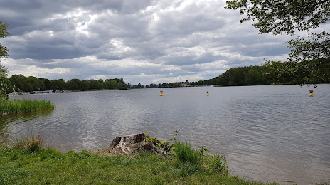
Photo
Where is located Weißer Strand am Lehnitzsee
Weißer Strand am Lehnitzsee — local attraction, which is located at no data and belongs to the category — -. Average visitor rating for this place — 4.3 (according to 38 ratings, information from open sources and relevant for 2022).
Exact location — Weißer Strand am Lehnitzsee, marked on the map with a red marker.
You can get directions to Weißer Strand am Lehnitzsee on the map from your location.
What else is interesting in Oranienburg? You can see all the sights if you go to the city page.
Coordinates
Weißer Strand am Lehnitzsee, Germany coordinates in decimal format: latitude — 52.75731716132855, longitude — 13.274563625365763. When converted to degrees, minutes, seconds Weißer Strand am Lehnitzsee has the following coordinates: 52°45′26.34 north latitude and 13°16′28.43 east longitude.
Nearby cities
The largest cities that are located nearby:
- Berlin — 30 km
- Potsdam — 42 km
- Szczecin
 (Poland) — 114 km
 - Magdeburg — 130 km
- Cottbus — 133 km
- Gorzów Wielkopolski (Poland) — 134 km
- Rostock — 165 km
- Leipzig — 167 km
- Wolfsburg — 169 km
- Zielona Gora (Poland) — 179 km
- Brunswick — 191 km
- Dresden — 192 km
- Salzgitter — 208 km
- Chemnitz — 214 km
- Gera — 222 km
- Hildesheim — 232 km
- Hanover — 240 km
- Koszalin (Poland) — 248 km
- Erfurt — 249 km
Distance to the capital
Distance to the capital (Berlin) is about — 28 km.