
 Józefów nad Wisłą
Gorzyce Wielkie
Rogówek
Sromowce Niżne
Wyszków County
Kruszewo
Jantar
Sady Górne
Nagoszewo
Józefów nad Wisłą
Gorzyce Wielkie
Rogówek
Sromowce Niżne
Wyszków County
Kruszewo
Jantar
Sady Górne
Nagoszewo
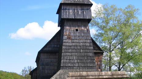
Skansen - Muzeum Budownictwa Ludowego on the map, Sanok, Poland
Photo
Where is located Skansen - Muzeum Budownictwa Ludowego
Skansen - Muzeum Budownictwa Ludowego — local attraction, which is located at 38-500 Sanok, Poland and belongs to the category — museum. Average visitor rating for this place — 4.8 (according to 222 ratings, information from open sources and relevant for 2022).
Exact location — Skansen - Muzeum Budownictwa Ludowego, marked on the map with a red marker.
You can get directions to Skansen - Muzeum Budownictwa Ludowego on the map from your location.
What else is interesting in Sanok? You can see all the sights if you go to the city page.
Coordinates
Skansen - Muzeum Budownictwa Ludowego, Poland coordinates in decimal format: latitude — 49.57409497167989, longitude — 22.20845047524922. When converted to degrees, minutes, seconds Skansen - Muzeum Budownictwa Ludowego has the following coordinates: 49°34′26.74 north latitude and 22°12′30.42 east longitude.
Nearby cities
The largest cities that are located nearby:
- Rzeszow — 56 km
- Tarnow — 100 km
- Uzhhorod
 (Ukraine) — 103 km
 - Košice
 (Slovakia) — 115 km
 - Kraków — 170 km
- Nyíregyháza
 (Hungary) — 181 km
 - Kielce — 182 km
- Lublin — 189 km
- Miskolc (Hungary) — 193 km
- Satu Mare
 (Romania) — 202 km
 - Radom — 217 km
- Bielsko-Biala — 226 km
- Debrecen (Hungary) — 228 km
- Dabrowa Gornicza — 229 km
- Baia Mare (Romania) — 233 km
- Sosnowiec — 234 km
- Katowice — 238 km
- Chorzow — 244 km
- Bytom — 248 km
Distance to the capital
Distance to the capital (Warsaw) is about — 307 km.