
 Puerto de la Duquesa
La Serna de Iguña
Pumalverde
Puentenansa
La Iglesia
Casar de Periedo
Fuengirola
Renedo de Piélagos
Villabanez
Puerto de la Duquesa
La Serna de Iguña
Pumalverde
Puentenansa
La Iglesia
Casar de Periedo
Fuengirola
Renedo de Piélagos
Villabanez
Área Recreativa de Gabenlle on the map, Carballo, Spain
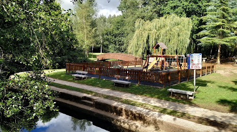
Photo
Where is located Área Recreativa de Gabenlle
Área Recreativa de Gabenlle — local attraction, which is located at Río Anllóns, Spain and belongs to the category — park. Average visitor rating for this place — 4.6 (according to 552 ratings, information from open sources and relevant for 2022).
Exact location — Área Recreativa de Gabenlle, marked on the map with a red marker.
You can get directions to Área Recreativa de Gabenlle on the map from your location.
What else is interesting in Carballo? You can see all the sights if you go to the city page.
Coordinates
Área Recreativa de Gabenlle, Spain coordinates in decimal format: latitude — 43.23868240703756, longitude — -8.570081174966214. When converted to degrees, minutes, seconds Área Recreativa de Gabenlle has the following coordinates: 43°14′19.26 north latitude and -8°34′12.29 east longitude.
Nearby cities
The largest cities that are located nearby:
- A Coruña — 28 km
- Vigo — 108 km
- Ourense — 118 km
- Braga
 (Portugal) — 186 km
 - Porto (Portugal) — 227 km
- Oviedo — 229 km
- Gijón — 245 km
- León — 263 km
- Coimbra (Portugal) — 334 km
- Salamanca — 354 km
- Valladolid — 370 km
- Santander — 393 km
- Burgos — 419 km
- Bilbao — 464 km
- Vitoria-Gasteiz — 489 km
- Amadora (Portugal) — 495 km
- Queluz (Portugal) — 495 km
- Lisbon (Portugal) — 498 km
- Badajoz — 501 km
Distance to the capital
Distance to the capital (Madrid) is about — 511 km.