
 Puerto de la Duquesa
La Serna de Iguña
Pumalverde
Puentenansa
La Iglesia
Casar de Periedo
Fuengirola
Renedo de Piélagos
Villabanez
Puerto de la Duquesa
La Serna de Iguña
Pumalverde
Puentenansa
La Iglesia
Casar de Periedo
Fuengirola
Renedo de Piélagos
Villabanez
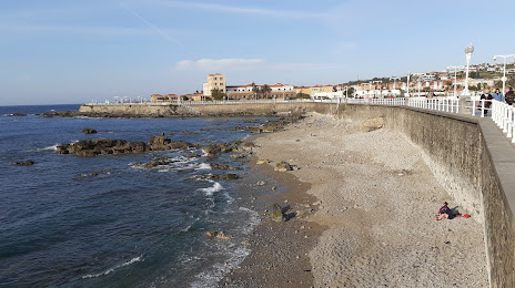
Playa de los Mayanes on the map, Gijón, Spain
Photo
Where is located Playa de los Mayanes
Playa de los Mayanes — local attraction, which is located at Asturias and belongs to the category — -. Average visitor rating for this place — 4.2 (according to 145 ratings, information from open sources and relevant for 2022).
Exact location — Playa de los Mayanes, marked on the map with a red marker.
You can get directions to Playa de los Mayanes on the map from your location.
What else is interesting in Gijón? You can see all the sights if you go to the city page.
Coordinates
Playa de los Mayanes, Spain coordinates in decimal format: latitude — 43.544763555232095, longitude — -5.643908808729001. When converted to degrees, minutes, seconds Playa de los Mayanes has the following coordinates: 43°32′41.15 north latitude and -5°38′38.07 east longitude.
Nearby cities
The largest cities that are located nearby:
- Oviedo — 24 km
- León — 103 km
- Santander — 149 km
- Burgos — 207 km
- Bilbao — 222 km
- Valladolid — 222 km
- A Coruña — 222 km
- Ourense — 223 km
- Vitoria-Gasteiz — 253 km
- Salamanca — 283 km
- Logroño — 288 km
- Vigo — 288 km
- San Sebastián — 297 km
- Braga
 (Portugal) — 317 km
 - Pamplona — 335 km
- Porto (Portugal) — 360 km
- Alcobendas — 372 km
- Alcorcón — 385 km
- Móstoles — 386 km
Distance to the capital
Distance to the capital (Madrid) is about — 383 km.