
 Gilserberg
Berlin
Bordesholm
Bechtolsheim
Aub
Triptis
Heppenheim
Biblis
Angermünde
Gilserberg
Berlin
Bordesholm
Bechtolsheim
Aub
Triptis
Heppenheim
Biblis
Angermünde
Museum Castellum on the map, Ginsheim-Gustavsburg, Germany
Photo
Where is located Museum Castellum
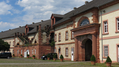
Museum Castellum — local attraction, which is located at Reduit, Kasteler Museumsufer, 55252, Germany and belongs to the category — heritage museum. Average visitor rating for this place — 4.6 (according to 27 ratings, information from open sources and relevant for 2022).
Exact location — Museum Castellum, marked on the map with a red marker.
You can get directions to Museum Castellum on the map from your location.
What else is interesting in Ginsheim-Gustavsburg? You can see all the sights if you go to the city page.
Coordinates
Museum Castellum, Germany coordinates in decimal format: latitude — 50.00642204993982, longitude — 8.281850925264752. When converted to degrees, minutes, seconds Museum Castellum has the following coordinates: 50°0′23.12 north latitude and 8°16′54.66 east longitude.
Nearby cities
The largest cities that are located nearby:
- Mainz — 6 km
- Wiesbaden — 12 km
- Darmstadt — 26 km
- Frankfurt — 28 km
- Offenbach — 34 km
- Mannheim — 56 km
- Ludwigshafen — 57 km
- Koblenz — 67 km
- Heidelberg — 69 km
- Siegen — 102 km
- Karlsruhe — 108 km
- Heilbronn — 113 km
- Würzburg — 118 km
- Bonn — 120 km
- Pforzheim — 123 km
- Trier — 124 km
- Saarbrücken — 127 km
- Bergisch Gladbach — 140 km
- Cologne — 142 km
Distance to the capital
Distance to the capital (Berlin) is about — 453 km.