
 Józefów nad Wisłą
Gorzyce Wielkie
Rogówek
Sromowce Niżne
Wyszków County
Kruszewo
Jantar
Sady Górne
Nagoszewo
Józefów nad Wisłą
Gorzyce Wielkie
Rogówek
Sromowce Niżne
Wyszków County
Kruszewo
Jantar
Sady Górne
Nagoszewo
Stajnia Morgan on the map, Inowroclaw, Poland
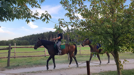
Photo
Where is located Stajnia Morgan
Stajnia Morgan — local attraction, which is located at Balczewo 46, 88-110, Poland and belongs to the category — stable. Average visitor rating for this place — 4.6 (according to 105 ratings, information from open sources and relevant for 2022).
Exact location — Stajnia Morgan, marked on the map with a red marker.
You can get directions to Stajnia Morgan on the map from your location.
What else is interesting in Inowroclaw? You can see all the sights if you go to the city page.
Coordinates
Stajnia Morgan, Poland coordinates in decimal format: latitude — 52.78449327956717, longitude — 18.379699125366788. When converted to degrees, minutes, seconds Stajnia Morgan has the following coordinates: 52°47′4.18 north latitude and 18°22′46.92 east longitude.
Nearby cities
The largest cities that are located nearby:
- Torun — 33 km
- Bydgoszcz — 39 km
- Wloclawek — 57 km
- Poznań — 100 km
- Plock — 101 km
- Kalisz — 115 km
- Łódź — 141 km
- Elblag — 167 km
- Gdańsk — 174 km
- Olsztyn — 181 km
- Gdynia — 191 km
- Gorzów Wielkopolski — 202 km
- Koszalin — 205 km
- Wrocław — 205 km
- Zielona Gora — 210 km
- Częstochowa — 228 km
- Legnica — 228 km
- Opole — 236 km
- Radom — 252 km
Distance to the capital
Distance to the capital (Warsaw) is about — 189 km.