
 Puerto de la Duquesa
La Serna de Iguña
Pumalverde
Puentenansa
La Iglesia
Casar de Periedo
Fuengirola
Renedo de Piélagos
Villabanez
Puerto de la Duquesa
La Serna de Iguña
Pumalverde
Puentenansa
La Iglesia
Casar de Periedo
Fuengirola
Renedo de Piélagos
Villabanez
El Coto Las Canteras on the map, Osuna, Spain
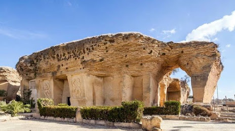
Photo
Where is located El Coto Las Canteras
El Coto Las Canteras — local attraction, which is located at Vía Sacra, s/n, 41640 Osuna, Sevilla, Spain and belongs to the category — historical landmark. Average visitor rating for this place — 4.3 (according to 430 ratings, information from open sources and relevant for 2022).
Exact location — El Coto Las Canteras, marked on the map with a red marker.
You can get directions to El Coto Las Canteras on the map from your location.
What else is interesting in Osuna? You can see all the sights if you go to the city page.
Coordinates
El Coto Las Canteras, Spain coordinates in decimal format: latitude — 37.24374434589224, longitude — -5.09953477514814. When converted to degrees, minutes, seconds El Coto Las Canteras has the following coordinates: 37°14′37.48 north latitude and -5°5′58.33 east longitude.
Nearby cities
The largest cities that are located nearby:
- Dos Hermanas — 72 km
- Córdoba — 77 km
- Marbella — 83 km
- Málaga — 83 km
- Jerez — 109 km
- Algeciras — 125 km
- Jaén — 130 km
- Cádiz — 131 km
- Granada — 133 km
- Huelva — 162 km
- Tangier
 (Morocco) — 176 km
 - Tetouan (Morocco) — 186 km
- Almería — 238 km
- Badajoz — 242 km
- Nador (Morocco) — 301 km
- Taounate (Morocco) — 302 km
- Albacete — 340 km
- Taza (Morocco) — 348 km
- Fuenlabrada — 355 km
Distance to the capital
Distance to the capital (Madrid) is about — 373 km.