
 Puerto de la Duquesa
La Serna de Iguña
Pumalverde
Puentenansa
La Iglesia
Casar de Periedo
Fuengirola
Renedo de Piélagos
Villabanez
Puerto de la Duquesa
La Serna de Iguña
Pumalverde
Puentenansa
La Iglesia
Casar de Periedo
Fuengirola
Renedo de Piélagos
Villabanez
Iglesia de San Marcos on the map, Jerez, Spain
Photo
Where is located Iglesia de San Marcos
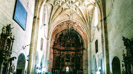
Iglesia de San Marcos — local attraction, which is located at Pl. Nuestro Padre Jesús de la Sagrada Cena, 8, 11403 Jerez de la Frontera, Cádiz, Spain and belongs to the category — edifice. Average visitor rating for this place — 4.7 (according to 292 ratings, information from open sources and relevant for 2022).
Exact location — Iglesia de San Marcos, marked on the map with a red marker.
You can get directions to Iglesia de San Marcos on the map from your location.
What else is interesting in Jerez? You can see all the sights if you go to the city page.
Coordinates
Iglesia de San Marcos, Spain coordinates in decimal format: latitude — 36.685750563270815, longitude — -6.138961575163903. When converted to degrees, minutes, seconds Iglesia de San Marcos has the following coordinates: 36°41′8.7 north latitude and -6°8′20.26 east longitude.
Nearby cities
The largest cities that are located nearby:
- Cádiz — 23 km
- Dos Hermanas — 69 km
- Algeciras — 85 km
- Huelva — 96 km
- Tangier
 (Morocco) — 106 km
 - Marbella — 112 km
- Tetouan (Morocco) — 141 km
- Málaga — 146 km
- Córdoba — 177 km
- Granada — 229 km
- Jaén — 238 km
- Badajoz — 253 km
- Kenitra (Morocco) — 272 km
- Taounate (Morocco) — 273 km
- Sale (Morocco) — 299 km
- Meknes (Morocco) — 313 km
- Temara (Morocco) — 313 km
- Khemisset (Morocco) — 317 km
- Almería — 325 km
Distance to the capital
Distance to the capital (Madrid) is about — 466 km.