
 Puerto de la Duquesa
La Serna de Iguña
Pumalverde
Puentenansa
La Iglesia
Casar de Periedo
Fuengirola
Renedo de Piélagos
Villabanez
Puerto de la Duquesa
La Serna de Iguña
Pumalverde
Puentenansa
La Iglesia
Casar de Periedo
Fuengirola
Renedo de Piélagos
Villabanez
Playa de Calamocarro on the map, Ceuta, Spain
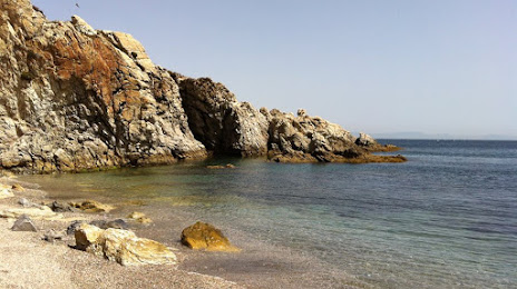
Photo
Where is located Playa de Calamocarro
Playa de Calamocarro — local attraction, which is located at N-354, 51004 Ceuta, Spain and belongs to the category — public bath. Average visitor rating for this place — 4.5 (according to 6 ratings, information from open sources and relevant for 2022).
Exact location — Playa de Calamocarro, marked on the map with a red marker.
You can get directions to Playa de Calamocarro on the map from your location.
What else is interesting in Ceuta? You can see all the sights if you go to the city page.
Coordinates
Playa de Calamocarro, Spain coordinates in decimal format: latitude — 35.91163461486819, longitude — -5.357284504728219. When converted to degrees, minutes, seconds Playa de Calamocarro has the following coordinates: 35°54′41.88 north latitude and -5°21′26.22 east longitude.
Nearby cities
The largest cities that are located nearby:
- Algeciras — 30 km
- Tetouan
 (Morocco) — 36 km
 - Tangier (Morocco) — 48 km
- Marbella — 79 km
- Cádiz — 111 km
- Jerez — 113 km
- Málaga — 114 km
- Taounate (Morocco) — 162 km
- Dos Hermanas — 163 km
- Granada — 208 km
- Huelva — 208 km
- Kenitra (Morocco) — 215 km
- Taza (Morocco) — 220 km
- Meknes (Morocco) — 222 km
- Córdoba — 226 km
- Nador (Morocco) — 230 km
- Khemisset (Morocco) — 239 km
- Sale (Morocco) — 244 km
- Jaén — 248 km
Distance to the capital
Distance to the capital (Madrid) is about — 522 km.