
 Bel-Ha
San Jose El Alto
El Porvenir
Nueva Palestina
Santa Lucía
Chemax
La Morita
Temoac
Zacualpan
Bel-Ha
San Jose El Alto
El Porvenir
Nueva Palestina
Santa Lucía
Chemax
La Morita
Temoac
Zacualpan
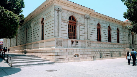
Museo Regional de Guerrero on the map, Chilpancingo, Mexico
Photo
Where is located Museo Regional de Guerrero
Museo Regional de Guerrero — local attraction, which is located at Plaza Cívica Primer Congreso de Anáhuac s/n Antonio, Lomas de San Antonio, 39000 Chilpancingo de los Bravo, Gro., Mexico and belongs to the category — museum. Average visitor rating for this place — 4.5 (according to 375 ratings, information from open sources and relevant for 2022).
Exact location — Museo Regional de Guerrero, marked on the map with a red marker.
You can get directions to Museo Regional de Guerrero on the map from your location.
What else is interesting in Chilpancingo? You can see all the sights if you go to the city page.
Coordinates
Museo Regional de Guerrero, Mexico coordinates in decimal format: latitude — 17.552102755980375, longitude — -99.50092647557194. When converted to degrees, minutes, seconds Museo Regional de Guerrero has the following coordinates: 17°33′7.57 north latitude and -99°30′3.34 east longitude.
Nearby cities
The largest cities that are located nearby:
- Acapulco — 86 km
- Iguala — 88 km
- Cuautla — 151 km
- Jiutepec — 151 km
- Cuernavaca — 155 km
- Metepec — 188 km
- Toluca — 192 km
- Chalco de Díaz Covarrubias — 200 km
- Ixtapaluca — 204 km
- Ciudad Nezahualcóyotl — 211 km
- Puebla — 213 km
- Chimalhuacan — 215 km
- Naucalpan — 215 km
- Tlalnepantla — 222 km
- Ciudad López Mateos — 223 km
- Texcoco — 225 km
- Buenavista — 229 km
- Ecatepec — 231 km
- Coacalco — 233 km
Distance to the capital
Distance to the capital (Mexico City) is about — 213 km.