
 Bel-Ha
San Jose El Alto
El Porvenir
Nueva Palestina
Santa Lucía
Chemax
La Morita
Temoac
Zacualpan
Bel-Ha
San Jose El Alto
El Porvenir
Nueva Palestina
Santa Lucía
Chemax
La Morita
Temoac
Zacualpan
El Almeal on the map, Huejutla de Reyes, Mexico
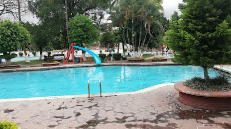
Photo
Where is located El Almeal
El Almeal — local attraction, which is located at Virginia Hernández S/N, Emiliano Zapata, 62744 Cuautla, Mor., Mexico and belongs to the category — water park. Average visitor rating for this place — 4.2 (according to 3560 ratings, information from open sources and relevant for 2022).
Exact location — El Almeal, marked on the map with a red marker.
You can get directions to El Almeal on the map from your location.
What else is interesting in Huejutla de Reyes? You can see all the sights if you go to the city page.
Coordinates
El Almeal, Mexico coordinates in decimal format: latitude — 21.141413808812587, longitude — -98.41385339479716. When converted to degrees, minutes, seconds El Almeal has the following coordinates: 21°8′29.09 north latitude and -98°24′49.87 east longitude.
Nearby cities
The largest cities that are located nearby:
- Tantoyuca — 30 km
- Tulancingo — 117 km
- Poza Rica de Hidalgo — 119 km
- Pachuca — 120 km
- Tampico — 134 km
- Ciudad Madero — 136 km
- Ojo de Agua — 174 km
- Coacalco — 182 km
- Ecatepec — 182 km
- San Juan del Río — 183 km
- Martínez de la Torre — 184 km
- Cuautitlán Izcalli — 186 km
- Texcoco — 187 km
- Buenavista — 187 km
- Tlalnepantla — 195 km
- Ciudad López Mateos — 196 km
- Chimalhuacan — 197 km
- Ciudad Nezahualcóyotl — 201 km
- Naucalpan — 202 km
Distance to the capital
Distance to the capital (Mexico City) is about — 204 km.